National Hurricane Center
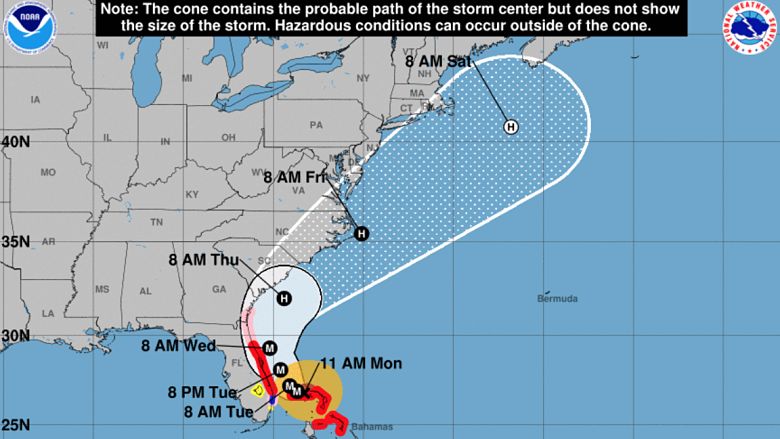
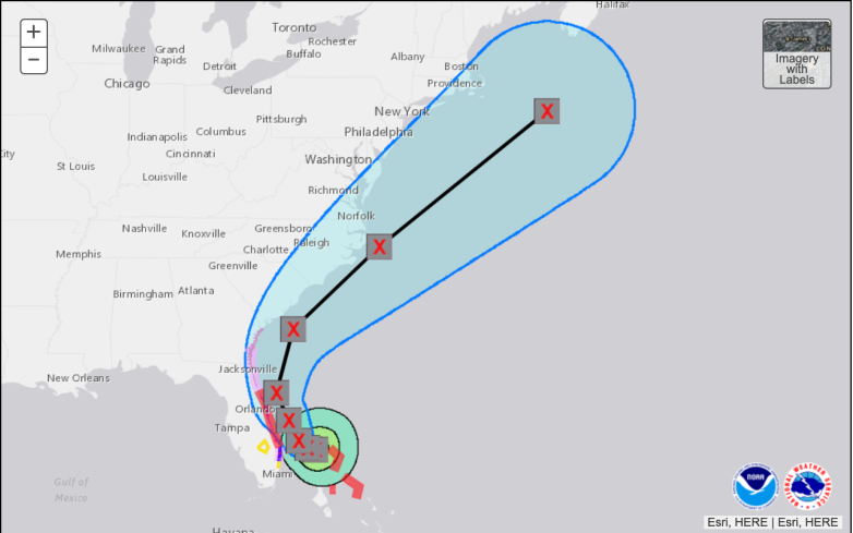
Hurricane Dorian is predicted to turn north and stay out in the Atlantic Ocean but folks in Florida are wondering exactly when that turn is going to be. The powerful storm is currently situated over Grand Bahama Island and is slowing moving west at 1 mph. From the looks of it, Dorian appears to have his sights set on Florida’s east coast. However, the storm’s latest track from the National Hurricane Center keeps it in the Atlantic, sparing Florida from catastrophic conditions.
The turn north is expected to occur over the next 12 to 24 hours. However, if the storm continues to stall — or stops moving altogether — that timeframe could be more like 24 to 36 hours.
“The NHC says Dorian is now wobbling to the west/northwest. A subtle turn to the Northwest and North should begin later tonight or Tuesday. Once that happens, Dorian will begin to accelerate. I get it. It’s terrifying to see this thing so close. I can’t imagine what folks in Grand Bahama, Freeport, and the Abacos are going through. For Florida though, the worst will stay offshore. Still surge, beach erosion and hurricane gusts, but nothing like what’s going on a 100 miles to the East. Hang in there. I truly believe a turn is on the way,” Tampa-area meteorologist Denis Phillips wrote in a Facebook post at noon Eastern on Monday, September 2.
The National Hurricane Center has issued a Hurricane Watch for the east coast of Florida from north of Deerfield Beach to the Volusia/Brevard County Line. Additionally, a Storm Surge Watch has been issued from north of Deerfield Beach to the Volusia/Brevard County Line.
A Tropical Storm Watch has been issued for Lake Okeechobee.
Here’s what you need to know:
A Slight Shift to the West Could See Dorian Making Landfall Along Florida’s East Coast but Meteorologists Don’t Think This Will Happen Because of a Trough Set to Guide the Storm North

National Hurricane Center
When Dorian was named a hurricane, the storm was predicted to make landfall in Florida. However, that was several days ago and the computer models have since changed. The main reason for that is Dorian’s speed. With the storm stalling over Grand Bahama Island, it’s allowing for the weakening of a ridge up north that has been guiding the storm west.
In addition to that weakening ridge, there’s also a trough of low pressure that will help guide Dorian, bringing him north, up the coast. The timing of these factors, however, is key.
Most meteorologists agree that Dorian will be pulled north, despite being just 110 miles from West Palm Beach, Florida.
Mandatory Evacuation Orders Are in Place for Several Coastal Communities in Florida & in South Carolina
Dorian is not expected to make landfall anywhere along the east coast but several areas are still in the National Hurricane Center’s “cone of uncertainty.” Due to this — and because the storm surge along Florida’s east coast is still expected to be significant, mandatory evacuation orders have been put into place.
On Sunday, September 1, Florida Governor Ron DeSantis is urged residents along Florida’s East Coast to obey all evacuation orders and warnings from local officials. Governor DeSantis has been holding regular press conferences and providing updates for those in the state.
The following counties have mandatory evacuation orders in place: St. Lucie County, Volusia County, St. John’s County, Putnam County, Palm Beach County, Nassau County, Martin County, Indian River County, Flagler County, Duval County, and Brevard County. Other counties have voluntary or phased evacuation orders in place.
You can see a full list with detailed explanations on the Florida Disaster Website.