NOAA
Hurricane Dorian was almost stationary yesterday as it hovered just north of Grand Bahama Island, but now the hurricane is slowly moving again. The storm will move close to Florida’s east coast late today through Wednesday night. Then it will be close to the Georgia and South Carolina coasts on Wednesday night and Thursday, according to the latest NOAA updates. It will be close to North Carolina’s coast late on Thursday. Many people want to keep an eye on the storm’s location on radar, along with local live stream web cams. Here is everything you need to see to watch the storm’s progression as it nears Florida, including 8 p.m. updates from NOAA. The first section will share live radars and streams to track the storm. The next sections will share live web cams so you can watch as the storm nears the coast. (Note: Some of these live streams may periodically go down or stop. We’ll look for new ones as that happens.)
The very last section has Dorian’s current coordinates from the NOAA for September 3.
Hurricane Dorian Live Streams, Trackers & Radars
This first live radar is from Windy.com. This radar is very helpful for tracking the storm’s lcoation. You can press the + button on the right-side of the map to zoom in more closely. You can also move the map ahead in time to see where the storm is forecast to be headed.
Here’s a live stream to track Dorian from Fox News.
Here’s 11 Alive’s maps and radar coverage.
Fox 10 Phoenix is offering live coverage.
And WPTV has live coverage, although it’s sometimes embedded as a picture-in-picture with their regular programming.
Live Web Cams from Florida
Here are live web cams from Florida that you’ll want to watch as the storm approaches. Some cams may appear dark at night, but will lighten up as the sun comes back up.
This stream is from Hollywood Beach, provided by NBC 6 South Florida.
This next stream is from Lake Worth Pier in Palm Beach County, Florida, but may periodically move to other streams too in the Florida region. It’s provided by Surfline.
This next video is from Deerfield Beach, Florida, provided by Ashchu117. Unfortunately, he’s temporarily lost his camera connection, but hopefully it’s back up soon.
And this shows a beach in Florida’s Port St. Lucie Inlet, provided by DZ.
Next is a live stream from a vehicle cam in Florida, provided by hurricanetrack as Mark Sudduth and Brent Lynn set up remote cameras in different parts of the state.
This next twitch stream rotates between different web cams in Florida, showing different beaches. It’s provided by HurriCams.
This twitch stream from Jennifer McMahans may show some interesting storm chasing coverage later as the storm approaches. This is from StormViewLive.
Here’s a live cam from Jacksonville, provided by Surfers View.
Redditor stereo0123 said he was streaming a few beach cameras on the east side of Florida. The only ones currently working are from Orlando.
The Sun has a live stream here from Dania Beach, Florida.
Live Web Cams from Other States
After Hurricane Dorian passes Florida, you’ll want to follow with live streams like these from locations in other states.
This next video from Explore Oceans shows a live feed of footage 34 miles seaward of Cape Fear, North Carolina. The storm likely won’t approach this region until much later.
This video from Lloyd Kenney III shows a live deer cam located in northwest Georgia. This area might get rain and winds as the storm approaches.
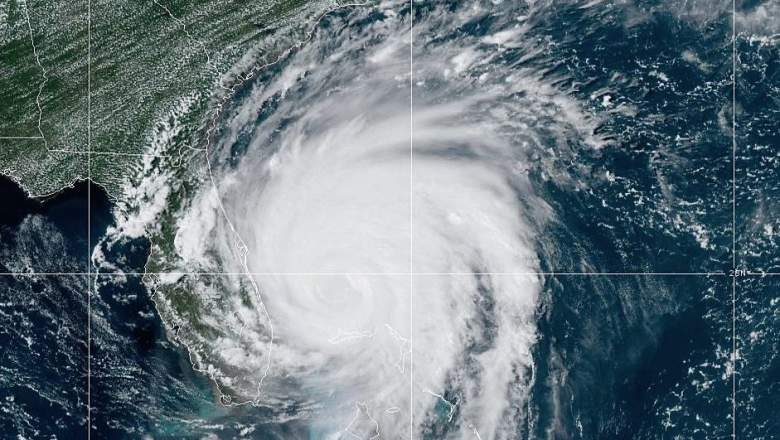
The latest update from NOAA, as of 8 p.m., says that Dorian is at 26.8N, 78.4W, located 25 miles northeast of Freeport, Grand Bahama Island, and 105 miles east of West Palm Beach, Florida. The storm is currently stationary, NOAA noted. Maximum sustained winds are 140 mph.
Dorian’s Location & Coordinates as of 8 PM, September 3
According to the National Hurricane Center on September 3 at 8 p.m., Hurricane Dorian is currently at 28.1 N, 78.8 W, about 110 miles east of Cape Canaveral, Florida.
Maximum winds are currently 110 mph, making the storm a Category 2. This is still a dangerous storm. Minimum central pressure is 959 mb (28.32 inches).
NOAA noted at 8 p.m.: “At 800 PM EDT (0000 UTC), the center of Hurricane Dorian was located near latitude 28.1 North, longitude 78.8 West. Dorian is moving toward the northwest near 6 mph (9 km/h), and a slightly faster motion toward the northwest or north-northwest is expected tonight. A turn toward the north is forecast by Wednesday evening, followed by a turn toward the north-northeast Thursday morning. On this track, the core of Hurricane Dorian will move dangerously close to the Florida east coast and the Georgia coast tonight through Wednesday night. The center of Dorian is forecast to move near or over the coast of South Carolina and North Carolina Thursday through Friday morning.
Maximum sustained winds are near 110 mph (175 km/h) with higher gusts. Dorian is expected to remain a powerful hurricane during the next few days. Dorian has become a larger hurricane. Hurricane-force winds extend outward up to 60 miles (95 km) from the center and tropical-storm-force winds extend outward up to 175 miles (280 km). NOAA buoy 41010 just north of the center recently reported a sustained wind of 67 mph (107 km/h) and a wind gust of 83 mph (133 km/h).
The latest minimum central pressure based on Air Force Reserve reconnaissance data is 959 mb (28.32 inches).”
A hurricane warning is in effect for:
- Sebastian Inlet, FL to Ponte Vedra Beach, FL
- North of Savannah River to Surf City, NC
A hurricane watch is in effect for:
- North of Ponte Vedra Beach, FL to Savannah River
- North of Surf City, NC to the North Carolina/Virginia border
- Albermarle and Pamlico Sounds
A tropical storm warning is in effect for:
- North of Ponte Vedra Beach, FL to Savannah River
- Grand Bahama and the Abacos Islands in the northwestern Bahamas
- Jupiter Inlet, FL to Sebastian Inlet, FL
A tropical storm watch is in effect for:
- The North Carolina/Virginia border to Chincoteague, VA
- Chesapeake Bay from Smith Point southward
READ NEXT: Florida Evacuation Zones, Maps, & Routes for Hurricane Dorian