
Inciweb
Some wildfires have exploded in size in California this week, even after PG&E attempted to cut down on fire risks by shutting down power in parts of southern California. Red flag weather conditions coupled with prolonged time with little rain created the perfect storm for fire growth. Here’s a look at the wildfires in California, including Saddleridge, Briceburg, Sandalwood, and more on Saturday, October 12. Parts of California have declared a state of emergency to help with fighting these fires.
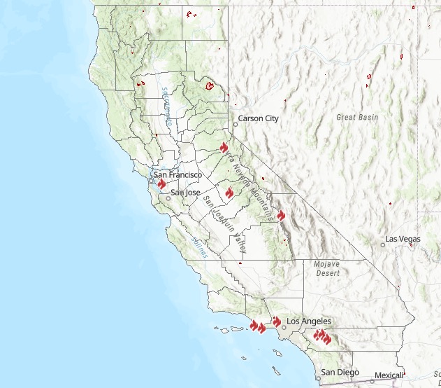
This article will first include interactive maps for all of California, including Cal Fire and other sources. You can use these maps to track reported fires in your area. They are updated periodically throughout the day. Then the second section details specific fires in the region in alphabetical order. If you’re looking for a specific fire, scroll down to that section or search for its name. Details like evacuations can change quickly, so stay tuned to your local news sources. When available, the sections on specific fires will also mention who you can follow for the latest updates.
Interactive Maps of California Fires
A number of interactive fire maps below can help you stay updated on the latest details about California fires. Don’t rely on just one map, since details can change quickly and some maps will have fires listed that others do not.
One of the best interactive maps available right now is Inciweb’s map. You can see the full map here. There’s an embeddable Google Map that includes Inciweb fires which you can see below. Depending on your browser, you may need to zoom into the map below using the + button within the map or change settings to only show Inciweb fires:

Another helpful interactive map is provided here from Ca.gov. A screenshot is below since the map can’t be embedded, but you’ll want to go to the full map for details, where you can input your address to see the fires near your location.
Ca.gov
A new interactive fire map is below, provided by UCANR.edu. Note that this map is only updated up to twice daily, so it may not be not as current as the two interactive maps above. Because of this, you may need to click “OK” on the map below to indicate that you’re not using it for emergency planning.
Newer fires may not be listed on the above maps until they’ve been around for a few hours.
Next are more specific details on the fires for Saturday, October 12, 2019. If you are looking for a specific fire, search for the name so you can find it faster, or just scroll down and look at the fires, listed in alphabetical order.
List of Active Fires in California on October 12, 2019
Here are the active fires and updates about them through late night on October 12, 2019. Most of these are in alphabetical order.
Bautista Fire
This fire is 167 acres and 100 percent contained as of October 8, according to Inciweb. The cause is under investigation. It was within the South Fork Wilderness.
Briceburg Fire
This fire started on October 6 and has grown quickly. It’s now 5,190 acres and 49 percent contained as of 6:54 a.m. Pacific on October 12. That’s an increase of five percent containment just since last night. The fire is in Mariposa County. The following interactive map is provided by MappingSupport.com showing satellite hotspots. This map may be about three hours behind present activity.
All mandatory evacuations and fire advisements have been lifted as of October 11, Ca.gov noted. Yosemite Park remains open.
Evacuation Centers:
- New Life Christian Fellowship, 5089 Cole Road, Mariposa, CA 95338
-
Small Animal Shelter: SPCA of Mariposa County 5599 CA-49, Mariposa, CA 95338(209)966-5275
-
Large Animal Shelter: Contact Mariposa Animal Control, (209)966-3615
A road closure is in place for Highway 140, 15 miles east of Mariposa (the top of the Briceburg Grade) to Savages Trading Post. Buffalo Gulch Road is open to residents only.
One structure was destroyed by the fire.
Broder Fire
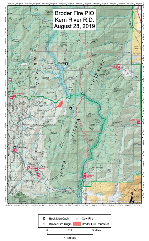
InciwebBroder Fire
This fire is 381 acres in size and 100 percent contained as of October 9. It was started by lightning on August 8. It’s northeast of Broder Meadow. Inciweb noted: “What heat remain is located deep within the perimeter of the fire and will continue to produce smoke for the time being.”
Caples Fire (Prescribed Burn)
Prescribed burns are purposefully set to help decrease the possibility of unexpected, damaging fires in the future. This one is in the northern ridge region above Caples Creek north of Highway 88. With ignitions completed, smoke is expected to lighten over the next few days.
The fire is 2,400 acres and 25 percent contained as of October 11 at 9:57 p.m., according to Inciweb. It’s still within the planned prescribed burn project area. On October 10, this was converted from a prescribed burn to a wildfire to allow for additional resources to maintain full suppression.
Cattle Fire
This fire is 92 acres and 100 percent contained as of October 9, according to Inciweb. It’s located in the “Kern River Ranger District SQF. 1 mile east (up river) from the Powerhouse (Bakersfield end)on Hwy. 178 between Bakersfield and Lake Isabella.”
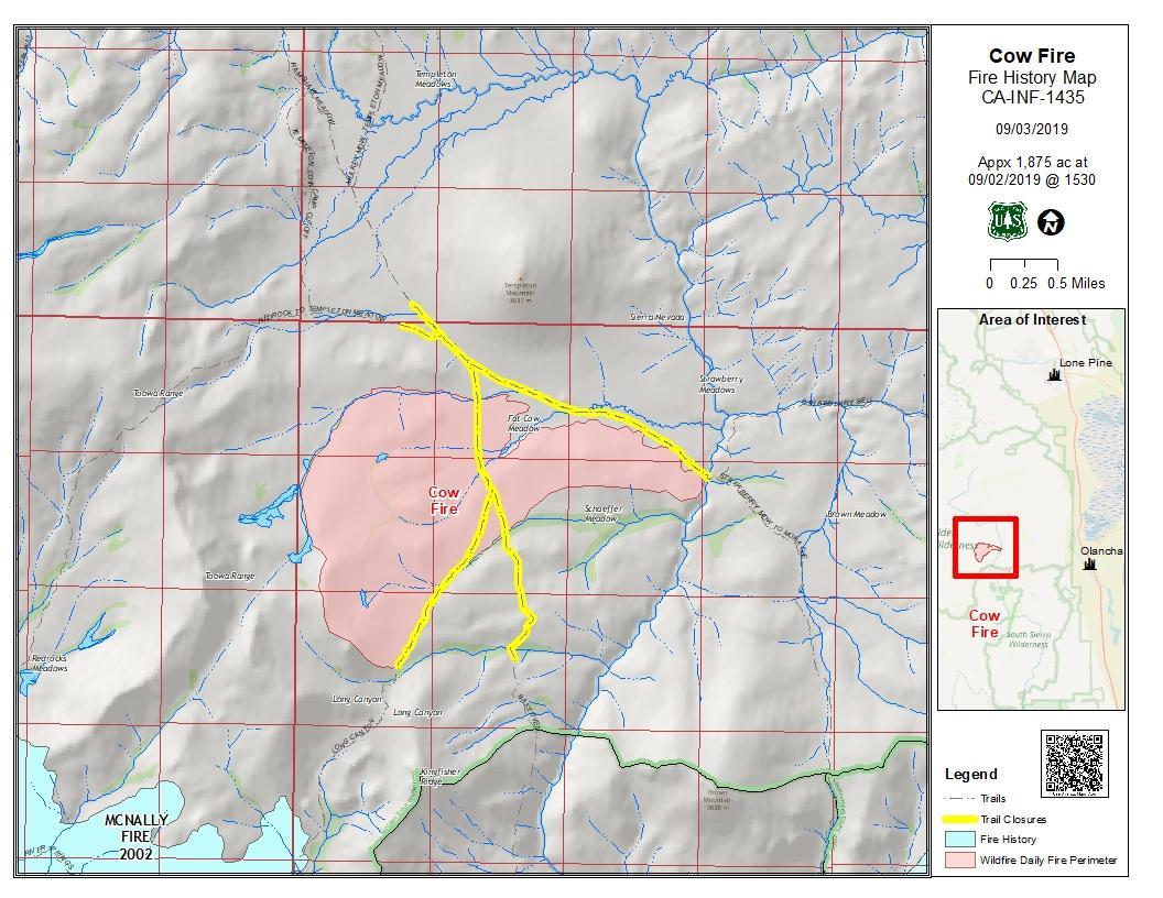
Cow Fire
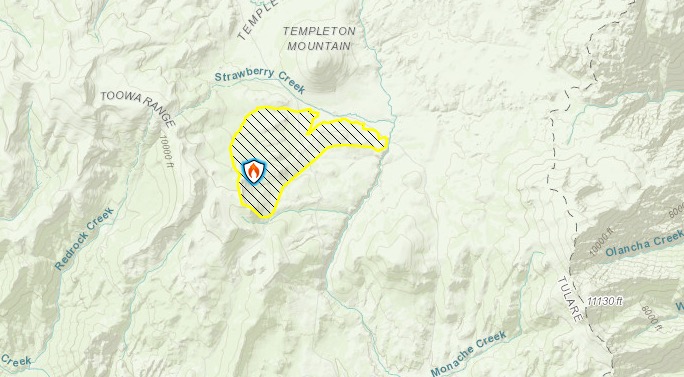
Inciweb
This fire is 1,975 acres in size and 30 percent contained, Inciweb noted on September 10, which is the last update provided by Inciweb. It was started by lightning on July 25. The map below is the last map released by Inciweb for the fire.
Inciweb
On October 8, Ca.gov noted about the fire: “Firefighters will continue to monitor the fire to ensure it stays within control lines. Containment will steadily increase as crews further secure control lines by identifying and extinguishing sources of heat along the fire perimeter.”
The fire’s burning in the Golden Trout Wilderness on Inyo National Forest. The fire’s being successfully confined and suppressed. Inciweb released its final official update on the fire on September 7, although it’s still listed as active on Ca.gov’s website. They wrote:
The 1,975-acre Cow Fire remains 30 percent contained. Minimal smoke may be visible from the Cow Fire until the area receives significant rainfall. Firefighters will continue to monitor the fire to ensure it stays within control lines. Containment will steadily increase as crews further secure control lines by identifying and extinguishing sources of heat along the fire perimeter.
The ecosystem within the Cow Fire footprint will benefit from the low-intensity fire effects observed on the landscape. Lightning-caused wildfires have a natural role to play in Eastern Sierra forest ecosystems…
The public is encouraged to avoid the fire area. Post-fire hazardous such as fire weakened trees and burning stump holes may be present.”
September 7 was the final Inciweb update for the fire due to good suppression efforts.
Evans Creek Fire
This fire is 25 acres and now 100 percent contained as of September 27, though it’s still listed as active on Inciweb’s map. It’s southwest of Reno, Nevada.
Fork Fire
Inciweb
This fire started on September 8 in the early evening, caused by lightning. It’s at Middle Fork Parker Creek, in South Warner Wilderness. The fire is currently 39 acres in size as of September 15, which is the last Inciweb update. The map above is the most recent map for the fire.
Inciweb noted: “The Fork Fire in the South Warner Wilderness is a full suppression fire being managed using tactics that will have a low impact and maintain wilderness character. The fire has burned 39 acres of primarily dead and downed fuels. Fire activity has been minimal as the fire slowly consumes surface fuels.”
Klamath NF Fall RX Burning
These are prescribed burns in the Klamath National Forest area to cut down on damage from unplanned fires.
Merrill Fire
This fire started on October 10. It’s 40 acres and 95 percent contained and located near Merrill Circle N and Merrill Dr in Moraga.
Middle Fire
Inciweb
The Middle Fire is 1,339 acres as of October 6 and now listed as 100 percent contained according to Inciweb. It was located one mile east of Canyon Creek Trailhead and was caused by lightning. It started on September 5 and is in the Trinity Alps Wilderness. “Please be aware that the forest’s Middle Fire Closure Order remains in effect until the fire is declared out.”
Olivas Fire
@joelmmathis Today a fire broke out near my brother’s house, but I believe it’s contained. He doesn’t even live in fire country. #OlivasFire
This fire started on October 11 at 3:57 p.m. in Ventura County. It’s 200 acres and 50 percent contained according to CA.gov on Friday night, the latest update. Other sources have said it’s now at 80 percent containment. It’s at Olivas Park Drive near Buenaventura Golf Course.
Ramshorn/SHF Lightning Fires 2019
The lightning fires from storms that moved into the area in September are now 100 percent contained and declared out, according to Inciweb.
Reche Fire in Moreno Valley
The Reche Fire was just discovered on Thursday, October 10 near Reche Canyon Road and Jordan Drive in Moreno Valley. The fire is in Riverside County and is now 350 acres in size and 85 percent contained, as of 7:39 a.m. on October 12. It’s in the 9000 block of Reche Canyon Road, according to Riverside County and burning at a moderate rate of speed. High tension power lines in the area may be threatened.
The fire started as a trailer fire and then spread to nearby vegetation.
All evacuation orders and road closures are lifted for this fire, Riverside County noted. Riverside County notes: “Please be mindful when driving through the fire area and yield to fire personnel and equipment working in the area. This is the final update for the evening unless significant activity warrants otherwise.”
Riverside County has an information sheet here with the latest updates on evacuations and other details.
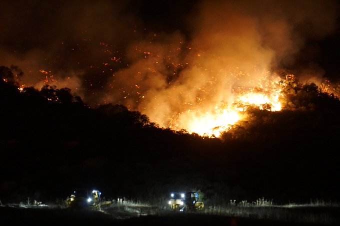
Saddleridge Fire

Inciweb
The Saddleridge Fire is much newer but has already exploded in size and caused tens of thousands to evacuate as it grows. Inciweb’s page for this fire is here. The fire is now 7,552 acres in size with 19 percent containment as of 7:34 a.m. Pacific on Saturday, October 12. Containment has increased by a few percentages even since Friday night, with 400 extra acres contained overnight. Firefighters took advantage of lower temperatures and decreased winds Friday night to continue reinforcing containment lines.
Another map showing the fire’s perimeters is below. You can see the full map here. The map lets you compare it to the perimeters of other fires from previous years also.
It started near I-210 at the Yarnell exit on October 10 around 9 p.m. Pacific. Wind gusts of up to 60 mph today could help the fire grow.
There has been one death and one injury from this fire so far: a civilian went into cardiac arrest and died on the way to the hospital, and one firefighter suffered a minor injury.
Below is an interactive map with satellite hotspots for the Saddleridge Fire from MappingSupport.com. Because the data is from satellites it could be three hours old. (Note: If the map is blank it may be because of server issues from so many people coming to view the map.)
So far, at least 31 structures are destroyed or damaged (13 are a 100 percent loss.)
Another map for Saddleridge is below, showing mandatory evacuation zones and the fire’s location. You will need to zoom into this map using the + button within the map to see it better.
Another interactive map, provided by the Los Angeles Fire Department, is below. You can click here to see the full-sized map. This is probably the best map to follow for evacuation updates.
Mandatory evacuations have been issued for the following areas, totaling 12,700 homes. This is provided by LAFD as of 12 p.m. Pacific on October 11.
- Porter Ranch North of 118FY from Reseda to Iverson
- Oakridge Estates (north of 210FY)
- West of Balboa, North of Sesnon to the Ventura County border with DeSoto as the western border
- LAFD noted on Friday: “Mandatory evacuation areas south of the 118 freeway will be reopened at 5pm. Community members returning to those areas should remain alert for fire activity. Any fire related emergencies or events should be reported to 911 immediately.”
Note: Los Angeles residents under mandatory evacuation had a chance to return to their homes for five minutes on Friday night at 5 p.m. to get documents, medicine, and small pets. They were able to do so once they were given escorts in and out of the area.
Evacuation centers are available at the following locations. This was provided by LAFD as of Friday evening unless otherwise noted. LAFD has not yet updated its Saddleridge page for Saturday as of the time of publication. We will update this story, but check here for updates too. Note that it may be good to call an evacuation center before showing up, as capacity details can change quickly.
- OPEN: Lanark Recreation Center (21816 Lanark St.) – Taking people and small pets.
- OPEN: Van Nuys Recreation Center (14301 Vanowen St. in Van Nuys, California)
- Encino Community Center (4935 Balboa Blvd., Encino California) (current status not known)
- OPEN: Northridge Recreation Center (18300 Lemarsh St) – Taking people and small pets
- FULL: Sylmar Recreation Center (13109 Borden Ave)
- OPEN: Granada Hills Recreation Center (16730 Chatsworth St.)
- FULL: Mason Park (10,500 Mason Ave)
- OPEN: Brandford Recreation Center (17015 Burbank Blvd.)
- OPEN: Hansen Dam (11770 Foothill Blvd) for large animals only
- OPEN: Pierce College (6201 Winnetka Ave.) for large animals only
- Canoga Discount Birds is accepting birds from evacuated residents, ABC 7 reported. (Since this is not officially listed by LAFD, you might want to call first.)
- Pomona Fairplex is also accepting large animals, ABC 7 reported. (Since this is not officially listed by LAFD, you might want to call first.)
- If you need help with the evacuation of large animals, contact East Valley Animal Shelter 818-756-9323
For road closure details, follow Caltrans District 7. As of Saturday, many road closures have now been reopened.
Stay updated on Saddleridge:
In addition to Inciweb’s page, Ca.gov is updating details about the fire here.
The best website for evacuation updates is from the Los Angeles Fire Department here or the embedded evacuation map from LAFD earlier in this section.
If you live in the LA area, sign up for updates about evacuations and other emergency alerts here: emergency.lacity.org/notifyla.
Inciweb is updating details about the fire here.
You can also text READY to NotifyLA at 888777 for updates on the fire, according to officials in a press conference today.
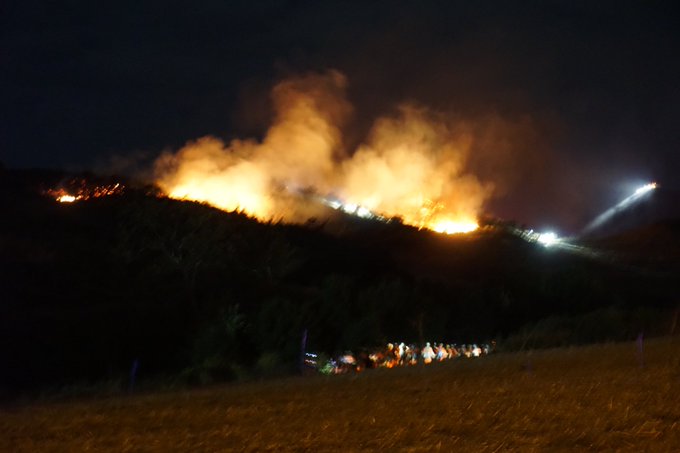
Sandalwood Fire in Calimesa near Yupaica
The Sandalwood Fire fire started on October 10 and has already caused extensive damage to a mobile park in the region called Villa Calimesa Mobile Home Park. The fire also poses a threat to the railway and power grid. A total of 74 structures were destroyed as of the morning of October 11, according to Riverside County, and 16 structures were damaged.
The fire started when a trash truck dumped a load of burning trash, which then spread to the nearby vegetation, Riverside County noted.
The fire is now 823 acres and 25 percent contained as of 7 a.m. on Saturday, October 12. Containment has increased from 10 percent the day before with no acreage growth, so this is a great sign.
The video below shows the fire as it was ripping through a mobile home park on October 10 when it first started.
According to Riverside County on the morning of October 12, all mandatory evacuations that were in place earlier are still in place. This includes.
- South of 7th Street, east of County Line Road
- Mesa View Middle School (Desert Sun reported on October 10)
Here is a map of the evacuation region. You can see the full map here.
Riverside County notes: “Reunification for residents and their pets can be done by contacting the Beaumont Police Department at (951) 769-8500 by leaving your name, address, phone number and a description of your pet(s). Your call will be returned. Some of the animals have been taken to the Ramona Animal Shelter. They can also be contacted during normal business hours Saturday from 8 a.m.- 5 p.m. and Sunday 8:00 a.m. – 3:00 p.m. at (951) 654-8002.”
Evacuation centers are in the following areas:
- Mesa Grande Academy at 975 Fremont Street, Calimesa, CA (opened at 7:30 p.m. on October 10. Transportation will be provided to evacuees at the Senior Center.)
- Large and small animals can be taken to the San Jacinto Valley Animal Campus at 581 S. Grand Avenue in San Jacinto. If residents need help getting their pets there, they can call 951-358-7387.
For the latest updates, follow Riverside County’s incident page. Cal Fire Riverside is also providing updates.
At least one person has died from the fire, but they have not yet been identified.
Shasta-Trinity Prescribed Fires
These are prescribed fires in the Shasta-Trinity National Forest area used to mitigate damage from unplanned fires in the future.
Sherman Prescribed Burn *
Prescribed burns are purposefully set to help decrease the possibility of unexpected, damaging fires in the future. These are in the Giant Forest area of Sequoia National Park.
South Fire
The South Fire started in Shasta-Trinity National Forest in Tehama County, located in the southeast aspect of Tomhead Mountain, south of Platina. As of October 11, the fire is now 5,332 acres in size and 100 percent contained, according to Inciweb. The fire is 15 miles south of Platina, California. The map above is the most recent map for the fire.
Inciweb notes that the plans for this fire are to “Monitor fire activity and patrol existing containment and confinement lines. Complete unfinished repair to Suppression Repair Plan standards. Be prepared to take appropriate action if fire crosses established Management Action Points.”
Springs Fire
This fire is now 4,840 acres and 100 percent contained according to Inciweb on October 7, the last update. It was caused by lightning. It’s located 13 miles southeast of Lee Vining.
Taboose Fire
InciwebFire map from September 24, the most recent map
This fire is 10,296 acres and 75 percent contained as of October 7, the most recent update on Inciweb. It’s southwest of Big Pine and northwest of Aberdeen. It was caused by lightning.
Inciweb noted: “The Taboose Fire has shown some interior smoke in the past several days along the western flank, where warming and drying of unburned fuels has allowed fire activity to increase. Currently, there are a few acres of active fire at high elevation, confined by rocks and burned areas. However, on the northern side of the active fire, there is an area of unburned fuels that the fire could grow into. With wind predicted on Tuesday, it is anticipated that the fire will remain active in this area…
Visitors and residents will see smoke, especially along the Hwy. 395 corridor. Please do not report the smoke. Currently, the south, east, and north flanks are secure and there is no threat to life or property.Gusty wind and low relative humidity are in the forecast for this week and fire crews will continue to monitor and patrol in areas where the fire is active.”
Walker Fire
This fire was first reported on September 4 and the cause isn’t known. On October 7, according to Inciweb, the fire is now 54,608 acres and 100 percent contained. It’s located east of Genesee near Indian Creek and Beckworth Genesee Road.
If you’re in Plumas County, you can sign up for emergency notices here. Or call 530-616-8625 for updates.
Wendy Fire in Newbury Park
The Wendy Fire started late in the day on October 10. It’s located off Potrero Road and S. Wendy Drive in Ventura County’s Newbury Park. The fire is 91 acres in size and 80 percent contained as of October 11, the most recent update.
Follow the Conejo Valley USD Twitter for updates about school closures.
As of 10:40pm all Newbury Park Schools, including Banyan Elem., are scheduled to be open tomorrow, Friday, October 11th. We continue to monitor the #WendyFire closely & be in active communication w/ local agencies. We are thankful to the @VCFD for their bravery & ongoing efforts.
Officials are saying that they are making good progress on this fire. There are no reported injuries or threatened structures at this time from the Wendy Fire.
UPDATE @VCFD: #wendyfire @VCFD_PIO says things are looking good. There are no reported injuries or structures threatened and approximately 91 acres. Some of my photos taken about 9:30pm #sharesocal @SpecNews1SoCal #venturacounty

According to VCFD PIO’s Twitter account, the fire is burning south away from Newbury Park. SoCal Edison had to shut off some power to Ventura County as a precaution.
Wolf Fire
This fire is 75 acres and 90 percent contained in Riverside County as of October 12. It’s located at Wolfskill Truck Road near Silver Creek Drive, south of Banning, Ca.gov noted.
All evacuation warnings have been lifted as of 5:20 p.m. on October 11.
The cause of this fire was a shooting. Riverside County notes: “A reminder to the public that hazardous fire area closures are still in effect and shooting isn’t allowed nor may the public enter private property with out the property owner’s permission. Any information on person(s) seen in the area during the start of the fire are urged to contact the Riverside County Arson Hotline at (800) 633-2836 and encourage the person to come forward as it was an accident.”
READ NEXT: PG&E Power Shutdown: Best Memes