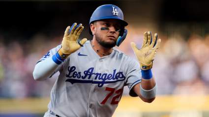
Florida Fire Maps: Track Fires Near Me Today [May 7]

Florida Fires Near Me

Florida Forest Service

A number of wildfires are burning in Florida today, May 7, as red flag conditions persisted. They include the Five Mile Swamp Fire in the Panhandle and other fires. Read on to see a map, photos of the fires, and more details about where they are located.


Florida Fire Maps

A Google Crisis map is available below, although you may need to zoom into Florida for more details. It shows advisories, warning, and InciWeb wildfire information. As of the time of publication, the Five Mile Swamp Fire wasn’t added to InciWeb, so it’s not showing up on the Google Crisis map.

You can see a wildfire dashboard of all the current active wildfires in Florida at this link. An embedded version is below. This map is updated every six hours at 6 p.m., 12 p.m., 6 a.m., and midnight. It’s provided by Florida government agencies.

And here’s another map, provided by the Florida Forest Service. You can see the full dashboard here.

According to the dashboards, there are 52 active wildfires (contained and not contained) in Florida as of May 7, including the following that are not contained:

  • Acey  Lowery Fire – 70 acres in size – Santa Rosa County
  • 5 Mile Swamp Fire – 2,000 acres in size in Santa Rosa County
  • L-67(6) Fire – 1,560 acres in Miami-Dade County (1,408 acres according to NIFC and 50% contained)
  • Dukes Island Fire – 10 acres in Volusia County
  • Glendale Drive Fire  – 90 acres in Washington County
  • Hurst Hammock 2 Fire – 1,000 acres in Escambia County and 40% contained
  • Mussett Bayou Fire – 575 acres in Walton County
  • North Grange Hall 2 Fire – 20 acres in Hillsborough County
  • 343 Wildfire – 169 acres in Levy County (340 acres according to NIFC and 78% contained)
  • Fox Fire – 920 acres and 95% contained according to NIFC
  • Oil Well Fire – 1 acre in Dixie County

You can also see a map of wildfires provided by the NWCG here. Zoom in to get a better look at the fires in Florida.

There are three fires in the Panhandle region. These include the Mussett Bayou fire at 575 acres and the Hurst Hammock 2 Fire at 1,000 acres, along with the 5 Mile Swamp fire at 2,000 acres and 40% containment. You can see a map of Panhandle fires below. The full map is here.


Here are more details on some of the active fires on the Florida Disaster dashboard:

5 Mile Swamp Fire

The following map, shared by Pensacola News Journal, shows the current location of evacuation recommendations. You can see the full map here. As of early evening May 6, the evacuations were recommended but not mandatory. This can change at any time, so it’s best to keep an eye on local updates if you’re in the area. Depending on your browser, you may need to zoom in to see the evacuation map’s details.

According to the Florida Disaster Map, this fire is 2,000 acres in size as of May 7. Learn more about the fire here.

Acey Lowery Fire

This fire in Santa Rosa County is 70 acres in size, according to the Florida Disaster Map.

Fox Fire

According to NIFC, this fire is 920 acres and 95% contained.

L-67 Fire

According to the Florida Disaster Map, this fire is 1,560 acres in Miami-Dade County.  NIFC lists the fire as being 1,408 acres and 50% contained, 19 miles west of Doral.

North Grange Hall 2 Fire

According to the Florida Disaster Map, this fire is 20 acres in Hillsborough County.

Glendale Drive Fire

This fire is 90 acres in Washington County, according to Florida Disaster Map.

Hurst Hammock 2 Fire

This fire is 1,000 acres in Escambia County and 40% contained. The Hurst Hammock 2 Fire isn’t currently threatening any homes, Weather.com reported. It grew quickly due to strong north winds and was burning toward the Perdido River.

Mussett Bayou Fire

This fire is 575 acres in Walton County, according to Florida Disaster Map. According to Weather.com, the Mussett Bayou Fire was caused by someone violating a burn ban who will be arrested soon. The fire is 60% contained. About 33 homes were destroyed and others damaged from the blaze.

020306 Fire

This one isn’t listed on Florida Disaster Map’s page, but NIFC lists it as 575 acres, 25% contained, and 4 miles east of Sandestine.

343 Fire

According to NIFC, this fire is 340 acres and 78% contained. It’s being managed by the Florida Forest Service and is 10 miles west of Williston.

READ NEXT: Daily COVID-19 Updates