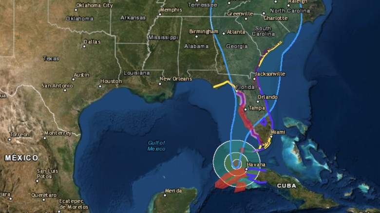
The National Hurricane Center has released weather updates for Hurricane Ian on September 27, 2022. These updates include new watch and warning areas, along with predictions for the storm that is slowly moving to the U.S. coast. You can read the full updates on the NOAA’s website here. Here’s a summary of the latest updates for the afternoon of September 27 as of 2 p.m. Eastern.
Hurricane Ian’s Location, Coordinates & Movement

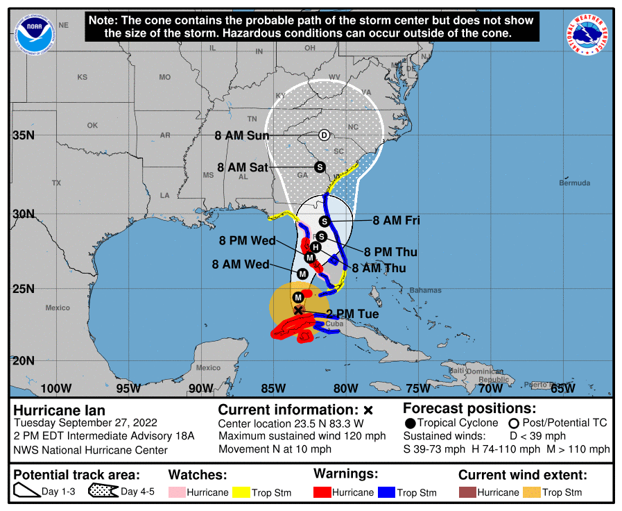
NHCIan map
As of 2 p.m. Eastern on Tuesday, September 27, the National Hurricane Center (NHC) provided a map of Ian’s projected path, which you can see above or via the link here. At that time, Ian was located 23.5N 83.3W, about 265 miles south of Sarasota, Florida, and about 85 miles south-southwest of The Dry Tortugas. (As of 3 p.m., this was 23.7N 83.3W, about 255 miles south of Sarasota, Florida, and 75 miles south-southwest of The Dry Tortugas.)
Maximum sustained winds were 120 mph and the storm was moving north or 10 degrees at 10 mph. This remained the same at the 3 p.m. Eastern update.
The minimum central pressure was 955 MB or 28.20 inches. (As of 3 p.m. Eastern, minimum pressure had decreased to 952 mb.)
The NOAA is warning that Ian will be an “extremely dangerous hurricane” as it approaches Florida to ultimately make landfall.
Current Watches & Warnings
According to the National Hurricane Center, the following warnings and watches are in effect as of 2 p.m. Please note that these can change quickly. (Note: These are quotes from the NOAA advisory.)
Hurricane Warning:
- Cuban provinces of Isla de Juventud, Pinar del Rio, and Artemisa
- Bonita Beach to Anclote River, including Tampa Bay
- Dry Tortugas
Tropical Storm Warning:
- Cuban provinces of La Habana, Mayabeque, and Matanzas
- Suwannee River to the Anclote River
- Flamingo to Bonita Beach
- Lower and Middle Florida Keys
- Boca Raton to Altamaha Sound
- Lake Okeechobee
Hurricane Watch:
- North of Anclote River to Suwanee River
- South of Bonita Beach to Chokoloskee
Tropical Storm Watch:
- North of Suwannee River to Indian Pass
- North of Altamaha Sound to South Santee River
- South of Boca Raton to east of Flamingo
- Upper Florida Keys
- Florida Bay
Storm Surge Warning:
- Suwanee River southward to Flamingo
- Tampa Bay
- Dry Tortugas
- Marineland to the mouth of the St. Mary’s River
- St. Johns River
Storm Surge Watch:
- Florida Keys from the Card Sound Bridge westward to Key West
- Florida Bay
- Aucilla River to Suwanee River
- Mouth of St. Mary’s River to South Santee River
- South of Marineland to the Volusia/Flagler county line
Landfall Predictions
This far out from landfall, predictions are still not exact. Hurricanes are known for sometimes changing direction rapidly and at the last minute. So if you are near the landfall region, you’ll want to keep a close eye on local news for changes.
The NOAA noted at 2 p.m. on September 27: “On the forecast track, the center of Ian is expected to move over the southeastern Gulf of Mexico today, pass west of the Florida Keys later tonight, and approach the west coast of Florida within the hurricane warning area on Wednesday and Wednesday night.”
In its discussion session, the NOAA spoke more about landfall predictions, writing:
There has been a notable trend toward the hurricane remaining more intact up through landfall, meaning Ian is likely to turn to the northeast and not move as slowly as previously anticipated. However, it should be emphasized that this track remains very uncertain, with a typical spread in the steering features leading to big speed and track differences down the line, not to mention the oblique angle of approach to Florida. The latest forecast is adjusted to the southeast for this advisory, showing
landfall 6-12 hours faster than before, and we will have to see if the southern trend continues in the afternoon guidance. The rest of the forecast after landfall has been adjusted to the northeast as well, though it is still slower than the consensus guidance at longer range…… the NHC intensity forecast continues to call for an extremely dangerous hurricane landfall for southwestern Florida.
ABC News reported that Ian could make landfall as early as late Wednesday afternoon in Florida between Tampa and Fort Myers.
ABC News noted the latest track showed flooding and damaging winds as a risk between Tampa and Fort Myers, and FEMA warned residents not to “underestimate” Ian.
Accuweather noted that Ian could strengthen to a Category 4 late Tuesday or Wednesday. It noted that Ian might lose intensity after it strengthens, and may not be a Category 4 by the time it makes landfall, but it will still be a very dangerous storm. Accuweather predicted Ian would make landfall in Florida on Wednesday night. Dangerous storm surge could be a risk for Tampa and areas south of Tampa.
READ NEXT: Hallmark Reveals Early Countdown to Christmas Lineup