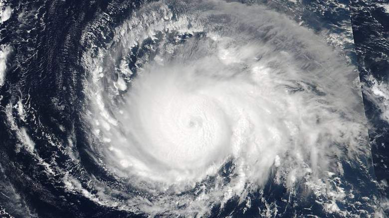
Getty Hurricane Irma from space.
Hurricane Irma is storming toward Puerto Rico and the Virgin Islands as a Category 5 storm with 185 mph winds. What are the chances that the hurricane will hit Orlando, Florida?
Southern Florida, such as the Florida Keys and Miami, were initially said to be in the most immediate peril on the continental United States (mandatory evacuation orders are being issued for the Keys). However, no one is certain what the storm will do after that, which is increasing anxiety. On September 6, The Orlando Sentinel reported: “Orlando and Central Florida are in the forecast cone of Irma’s potential path,” adding, “Central Florida could start feeling tropical storm wind impacts from the storm as early as Saturday morning.” You can see that cone graphic here:
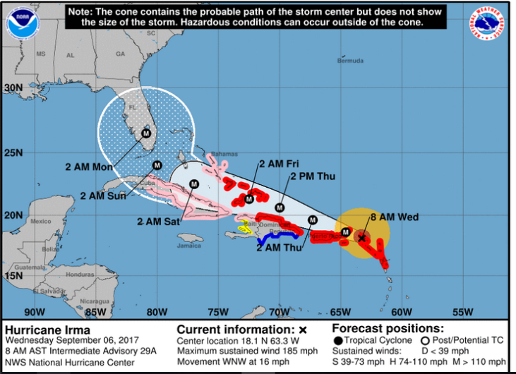
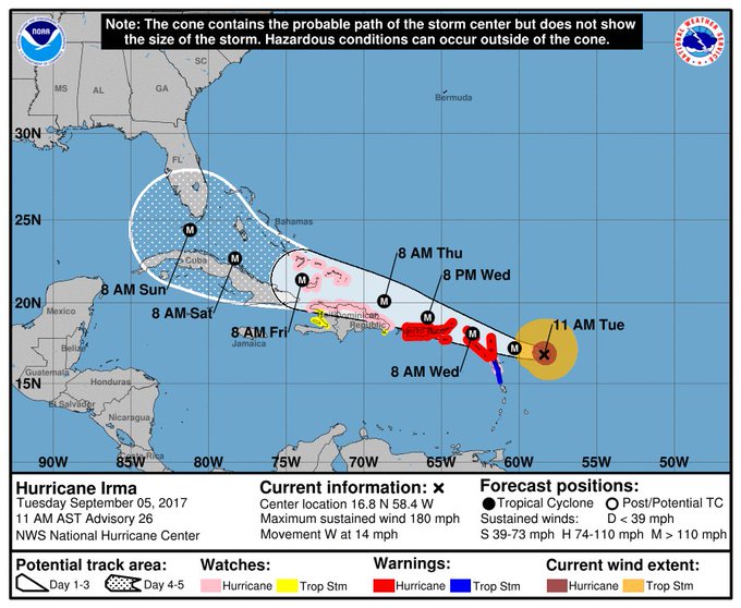
The September 6 morning forecast path for Hurricane Irma.
Furthermore, for the first time on September 6, the National Weather Service said that hurricane conditions were possible for Orlando on Sunday, as well as tropical storm conditions on Saturday.

“Forecasters said the storm has continued to move closer to Florida, and there is an ‘increasing chance’ that it will impact the state,” reported the Sentinel of Irma, which made landfall in Barbuda overnight with Puerto Rico next in line.
The forecasts show that Orlando is likely to see some impact from Irma in terms of rain and wind, but there was not a hurricane watch or warning for the city on September 6.
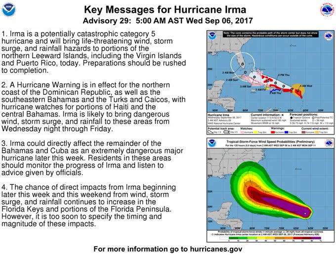
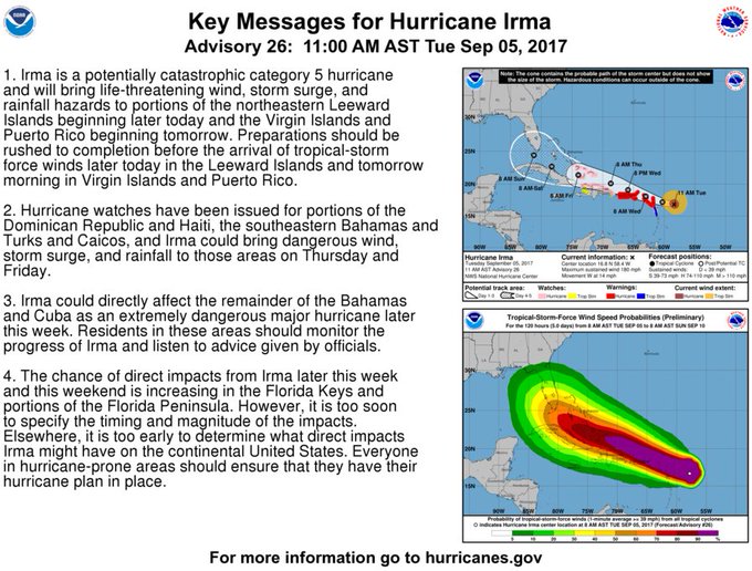
5 AM AST forecast and key messages for Hurricane #Irma. Go to t.co/tW4KeGdBFb for the latest forecast.
The hazardous weather outlook for Orlando for September 6 reported, “While forecast for this weekend still remains somewhat uncertain, Major Hurricane Irma is forecast to move west-northwest into the eastern Florida Straits on Saturday, then turn north and make its closest approach to central Florida, through Sunday night or early Monday. While it is still too early to be specific about direct impacts that Irma will have on east central Florida, there is an increasing likelihood that Irma will produce a significant deterioration of weather conditions as it passes by.”
“It’s already the strongest hurricane ever recorded outside the Caribbean and the Gulf of Mexico, and it’s likely to make landfall somewhere in Florida over the weekend,” The Washington Post reported. Read about the potential impact on Disney World here.
“All of Florida — especially South Florida and the Keys — should be preparing for a major hurricane landfall on Sunday. Tropical-storm-force winds are expected to arrive as soon as Friday.” The Post noted of the storm’s unpredictability: “Computer models are in strong agreement that by Saturday, Irma will be approaching the Florida Keys — where dangerous storm conditions are likely. Then, they show a sharp northward turn by Sunday morning. The precise timing and location of the turn has huge implications for Florida.” It’s not clear how the storm will track after that, The Post reported – east Florida, west Florida or straight up into the state.
“Irma has become one of the most powerful storms in history with the National Hurricane Center calling it ‘potentially catastrophic,'” reports The Orlando Sentinel. “It’s tied with Hurricane Wilma as the second strongest storm that’s formed in the Atlantic Ocean on record, both just behind Hurricane Allen in 1980, which had wind speeds of 190 mph.”
#Irma key messages for Advisory 26. #Hurricane preparations should be rushed to completion in the NE Caribbean. t.co/tW4KeGdBFb
Gov. Rick Scott activated the Florida Air and Army National Guard and declared a state of emergency in Florida. You can see the latest radar for Orlando, Florida here. Note that Orlando’s weather forecasts come out of the Melbourne, Florida office of the National Weather Service. See an hourly forecast for Orlando here. See infrared satellite maps here.
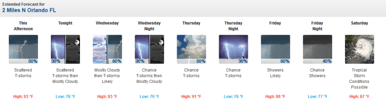
Orlando forecast as of September 5 in the afternoon.
The National Weather Service’s hazardous weather outlook for east central Florida, including Orlando, reads as follows on the afternoon of September 5:
“DAY ONE…TODAY AND TONIGHT..THUNDERSTORM IMPACT…Isolated lightning storms are forecast to develop near the coast as the Atlantic sea breeze pushes inland early this afternoon. Storm coverage will increase over the interior counties from mid to late afternoon as the sea breeze begins to interact with other boundaries. A few storms could become strong with winds gusts of 40 to 50 mph, frequent cloud to ground lightning strikes, and very heavy rainfall the primary weather hazards.”
“FLOOD IMPACT…Locally heavy rain in slow moving storms will be possible this afternoon, especially across the inland counties. Rainfall amounts between 2 and 3 inches in a short time period will produce ponding of water on roadways and flooding in poor drainage areas. RIP CURRENT IMPACT…A long period swell will maintain a moderate risk for dangerous rip currents at area beaches today. Check with local beach patrol before entering the water and never swim alone! MARINE THUNDERSTORM GUST IMPACT… Afternoon storms will be capable of generating wind gusts in excess of 30 knots, mainly over inland lakes of east central Florida.”
New #hurricane watches have been issued for the Turks & Caicos Islands, SE Bahamas & the north coast of #Haiti t.co/tW4KeGdBFb #Irma
“DAYS TWO THROUGH SEVEN…WEDNESDAY THROUGH MONDAY. Shower and thunderstorm chances will increase to above normal from Wednesday onward as an early season cool front sags into north Florida and stalls. The forecast for this weekend remains somewhat uncertain as Major Hurricane Irma moves into the Florida Straits and makes its closest approach to central Florida, probably around Sunday. While it is still too early to be specific about any direct impacts that Irma will have on east central Florida, there is an increasing likelihood of as least some impact from the system. Increasing rain chances and increasingly windy conditions are likely this weekend, and boating and surf conditions are expected to become increasingly hazardous by late week, and dangerous by this weekend.”
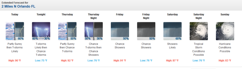
The detailed weather forecast for Orlando was as follows on September 6:
“Today (September 6)
Showers and thunderstorms likely after 1pm. Mostly cloudy, with a high near 90. Calm wind becoming south around 5 mph in the afternoon. Chance of precipitation is 60%. New rainfall amounts between a tenth and quarter of an inch, except higher amounts possible in thunderstorms.
Tonight
Showers and thunderstorms likely, mainly before 9pm. Mostly cloudy, with a low around 75. West northwest wind around 5 mph becoming calm in the evening. Chance of precipitation is 60%. New rainfall amounts between a tenth and quarter of an inch, except higher amounts possible in thunderstorms.
Thursday
A 50 percent chance of showers and thunderstorms after noon. Partly sunny, with a high near 92. Northeast wind around 5 mph. New rainfall amounts between a tenth and quarter of an inch, except higher amounts possible in thunderstorms.
Thursday Night
A 50 percent chance of showers and thunderstorms before 3am. Mostly cloudy, with a low around 76. East northeast wind 5 to 10 mph.
Friday
A 50 percent chance of showers and thunderstorms after 9am. Mostly cloudy, with a high near 91. North northeast wind 5 to 15 mph.
Friday Night
A 50 percent chance of showers and thunderstorms. Mostly cloudy, with a low around 76. Northeast wind 10 to 15 mph.
Saturday
A chance of showers and thunderstorms, then showers likely and possibly a thunderstorm after 9am. Mostly cloudy, with a high near 87. Northeast wind 10 to 15 mph, with gusts as high as 20 mph. Chance of precipitation is 60%.
Saturday Night
Tropical storm conditions possible. Showers likely and possibly a thunderstorm. Cloudy, with a low around 76. Chance of precipitation is 60%.
Sunday
Hurricane conditions possible. Showers likely and possibly a thunderstorm. Cloudy, with a high near 83. Chance of precipitation is 70%.
Sunday Night
Showers likely and possibly a thunderstorm. Cloudy, with a low around 74. Windy, with an east northeast wind 15 to 25 mph, with gusts as high as 35 mph. Chance of precipitation is 70%.
Monday
Showers likely and possibly a thunderstorm. Mostly cloudy, with a high near 83. Windy, with an east northeast wind 40 to 45 mph decreasing to 30 to 35 mph in the afternoon. Winds could gust as high as 55 mph. Chance of precipitation is 60%.
Monday Night
Showers and thunderstorms likely. Mostly cloudy, with a low around 74. Windy, with a southwest wind around 20 mph, with gusts as high as 30 mph. Chance of precipitation is 60%.
Tuesday
A 30 percent chance of showers and thunderstorms. Mostly sunny, with a high near 88. West southwest wind around 15 mph, with gusts as high as 25 mph.”