National Hurricane Center
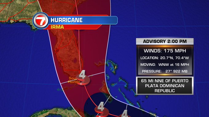
As Hurricane Irma gets closer and closer to southern Florida and the mainland United States, many are wanting to know the latest details about West Palm Beach and Palm Beach County evacuations. The storm is currently located at latitude 20.7 N, longitude 70.4 W as of 2 p.m. It’s moving west-northwest at 16 mph and is expected to continue this course of the next couple of days, the National Hurricane Center reported. Maximum sustained winds are at 175 mph, a drop from its original 185 mph, but still at catastrophic levels. Irma is forecast to either be a Category 4 or 5 over the next couple days.
Here’s what we know so far.
The Entire Town of Palm Beach Is Under an Evacuation Order
The entire town of Palm Beach is under an evacuation order for the island:

Town of Palm Beach orders evacuation @CBS12

At the time of the announcement, West Palm Beach had not yet made a decision. Gov. Scott told residents of West Palm Beach on Thursday afternoon to be prepared to evacuate if they’re told to do so.
Palm Beach Post reported on Thursday that they expected evacuations to be ordered in Palm Beach County for barrier islands and areas prone to storm surges sometime that day. If leaving homes, however, residents are urged to stay within Palm Beach County, said Bill Johnson, head of the city’s emergency management department.
Mayor Jeri Muoio tweeted on Sept. 6 that they would know better on Thursday what to advise because they were still unclear about the hurricane’s path. As of Thursday afternoon, she hasn’t updated that tweet yet.
Residents are urged to know their evacuation zones in case an alert goes out. If you aren’t sure which evacuation zone you’re in, you can visit here to find out. If the city orders an evacuation, you should leave, officials have said, because emergency responders can’t help you in the middle of a hurricane. Evacuations are only ordered because of a threat of flooding, not wind, emergency managers have said.
Palm Beach Post reported that at this point, driving is likely the only option for evacuating, since most flights out of Palm Beach, Fort Lauderdale and Miami are booked. In southern Georgia, hotel rooms are getting tough to find, so the further north that evacuees go, the better.
But gas is getting tough to find, so you’ll want to conserve your fuel if you’re thinking of leaving. Palm Beach County emergency managers said today that demand for fuel is outpacing supplies, so residences were being advised to shelter within their county in areas not under evacuation orders.
Gov. Scott said they are moving fuel into the state to address the shortages that many have noticed. Only take as much fuel as you need, and use apps like GasBuddy or Waze to help you determine what stations have fuel.
To help with evacuations, all weight and driver restrictions have been rescinded on the highways, and all tolls have been suspended. Sen. Marco Rubio said that all preparation and evacuations should be finished by Friday.
Meanwhile, West Palm Beach and Palm Beach County residents are preparing for the hurricane’s arrival. Demolition crews are clearing their sites in downtown West Palm Beach. Cranes will be set to swivel with the wind so they don’t snap, Palm Beach Post reported.
Please note the 2017 Palm Beach County risk shelters with evacuation zones. #HurricaneIrma
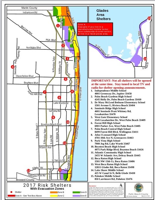
According to the Sun-Sentinel, the following 15 shelters are available starting at 10 a.m. Friday in Palm Beach County:
Atlantic High School, 2455 W Atlantic Ave. in Delray Beach; Boca Raton High School, 1501 NW 15th Court; Boynton Beach High School, 4975 Park Ridge Blvd.; Dr. Mary McLeod Bethune Elementary School, 1501 Avenue U in Riviera Beach; Forest Hill High School, 6901 Parker Ave. in West Palm Beach; Independence Middle School, 4001 Greenway Drive in Jupiter; John I. Leonard High School, 4701 10 Ave. in Greenacres; Lakeshore Middle School, 425 W. Canal St. N. in Belle Glade; Palm Beach Central High School, 8499 Forest Hill Blvd. in Wellington; Palm Beach Gardens High School, 4245 Holly Drive; Park Vista High School, 7900 Jog Road in Lake Worth; Pahokee Middle School, 850 Larrimore Road in Pahokee; Seminole Ridge High School, 4601 Seminole Pratt Whitney Road in Loxahatchee; West Boca High School, 12811 Glades Road; and Westgate Elementary, 1545 Loxahatchee Drive in West Palm Beach. Residents going to shelter need to bring their own water, clothes and medication.
In addition, a pet-friendly shelter opens 10 a.m. Friday at West Boynton Recreation Center, 6000 Northtree Blvd. in Lake Worth. It’s only available to Palm Beach County residents in a mandatory evacuation zone or in mobile homes. Proof of residency is required. Each pet must be accompanied by only one owner and other family owners must stay elsewhere.
Details About Hurricane Irma
Key Messages on Hurricane #Irma as of 11 am AST/EDT:
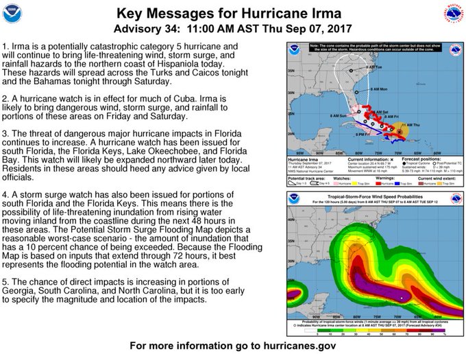
According to the 11 a.m. advisory from the National Hurricane Center, the threat of impacting Florida is continuing to increase. A hurricane watch has been issued for south Florida, the Florida Keys, Lake Okeechobee, and Florida Bay. By later today, this watch area will be expanded most likely.
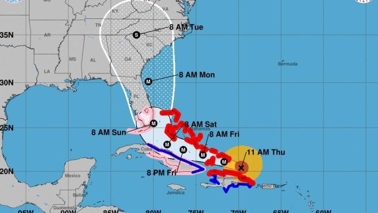
Here is the latest forecast track on #Irma
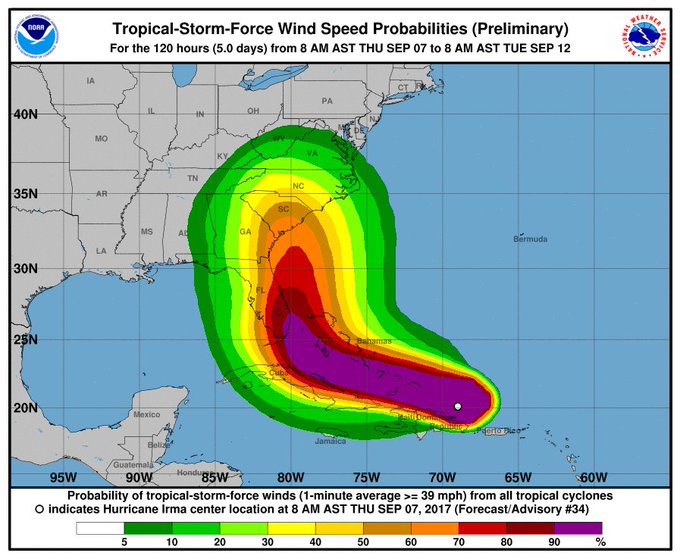
Irma’s track doesn’t tell you enough. Check out this map for the probably of tropical storm force winds in your area:
Don’t focus on the exact track of #Irma. There is a high probability of trop storm and hurricane conditions well away from the center.
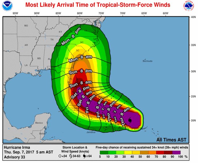
The National Hurricane Center shared this graphic showing the most likely arrival time for tropical storm force winds. This isn’t the worst of the hurricane, it’s just the time you’ll start feeling the hurricane. Hurricane force winds will extend outward about 60 miles from the center of a hurricane, while tropical storm force winds extend outward up to 185 miles from the center.
For south Florida, that looks like Saturday morning or Saturday evening at the latest.
Hurricane watches will likely be issued for parts of FL today. TS winds expected to arrive in south FL and the Keys on Saturday #Irma
As of 11:30 a.m., according to the NHC, the following watches and warnings had been issued for the South Florida area.
CHANGES TO WATCHES AND WARNINGS:
– A Storm Surge Watch and Hurricane Watch have been issued for Coastal Broward, Coastal Collier, Coastal Miami-Dade, Coastal Palm Beach, Far South Miami-Dade, Inland Collier, Inland Miami-Dade, Mainland Monroe, and Metro Miami-Dade
– A Hurricane Watch has been issued for Glades, Hendry, Inland Broward, Inland Palm Beach, Metro Broward, and Metro Palm Beach* CURRENT WATCHES AND WARNINGS:
– A Storm Surge Watch and Hurricane Watch are in effect for Coastal Broward, Coastal Collier, Coastal Miami-Dade, Coastal Palm Beach, Far South Miami-Dade, Inland Collier, Inland Miami-Dade, Mainland Monroe, and Metro Miami-Dade
– A Hurricane Watch is in effect for Glades, Hendry, Inland Broward, Inland Palm Beach, Metro Broward, and Metro Palm BeachHurricane Irma is forecast to move west northwest across the
Bahamas today and into Friday, before impacting South Florida this
weekend and into early next week. The main concerns for South Florida
at this time are the potential for destructive winds and life-
threatening storm surge. The main window of concern for Hurricane Irma
impacts is early Saturday morning through Monday.Additional concerns exist for flooding rains, isolated tornadoes,
significant beach erosion and surf, coastal flooding, and life-
threatening rip currents.At this time, all interests in South Florida should continue to
closely monitor the progression of Hurricane Irma. Continue to remain
informed with the latest information and forecasts.All interests in South Florida are urged to complete hurricane
preparations by the end of the day Friday.
Read the full warning, including potential impacts, here.
Residents are urged to be vigilant and stay tuned to local weather forecasts.