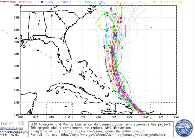
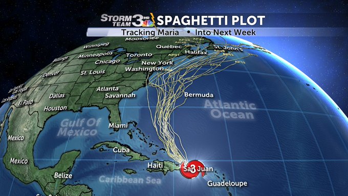
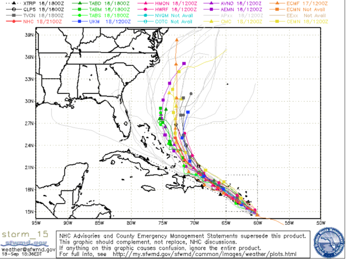
SFWMD Spaghetti model for the evening of September 20 for Hurricane Maria.
Hurricane Maria is unleashing her wrath on Puerto Rico, Wednesday, but what are the chances that Maria will strike Florida and the coast of the United States?
The latest spaghetti models for the evening of September 20 show that the storm is still projected to shift to the north after striking Puerto Rico, which would be good news for Florida, as they still show the storm bypassing the state. The models also show that the storm might miss the entire east coast altogether, and states like Georgia and the Carolinas are in far less peril than they seemed to be a few days ago. As the storm has shifted, it’s the northeast coastline that is in the most peril from Maria in the storm’s later stages, although a direct hit there is also far from certain. After all, Hurricane Jose was on a similar course, and it ended up staying out to sea without causing much damage on the east coast.
(Update: The September 21 models show the storm moving even farther away from the U.S. east coast. You can see that post here.)
The most pressing concern right now is for Puerto Rico, which was in the immediate path of the storm on Wednesday. The eye of the storm, with 150 mph winds, was over Puerto Rico on September 20, according to The National Hurricane Center. All of Puerto Rico was without power, as flash floods and strong winds caused dramatic scenes of damage.


Cyclocane is one of the best sites to track real-time Hurricane Maria spaghetti models. You can see the site’s Hurricane Maria spaghetti model map here. See other maps and satellite paths for Maria here.
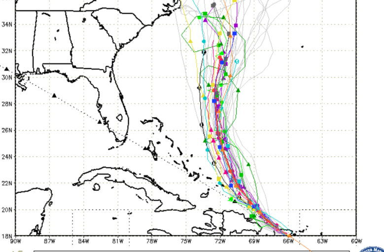
The South Florida Waste Management District also has a regularly updated spaghetti model plot for Maria. To see the latest plot, click here and choose “Storm 15.” Here’s the plot on the evening of September 20:
Hurricane Maria spaghetti model for the evening of September 20.
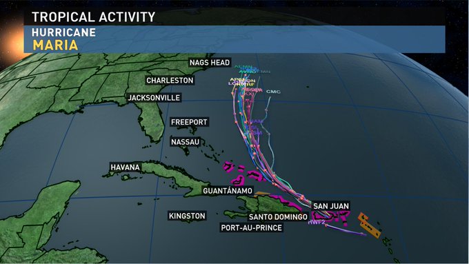
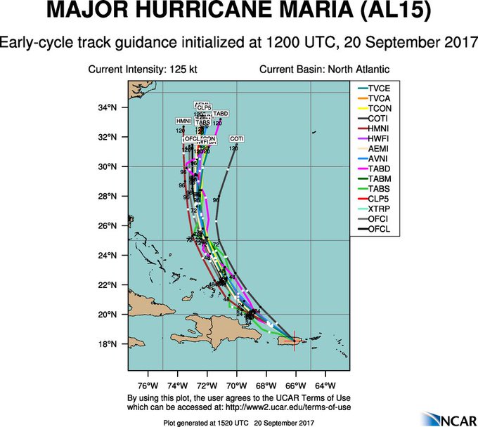
Here are some of the other latest spaghetti models showing the storm’s projected path:
The spaghetti plots for Hurricane Maria through early Tuesday morning. The storm has weakened a little.

Latest model forecast track guidance in strong agreement on Hurricane #Maria recurve N just east of Turks and Caicos
Latest computer model forecasts for #Hurricane #Maria. Thankfully it will miss the southeast U.S. coast.
Other models tell a similar story:
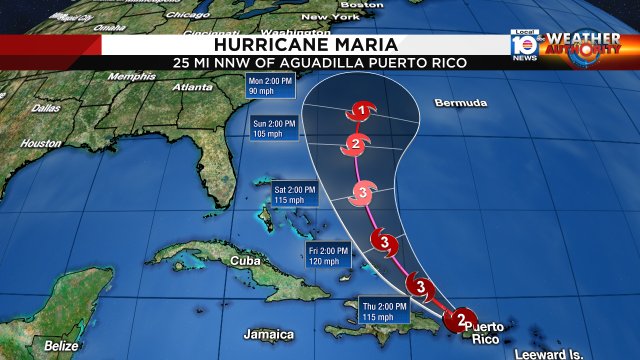
As of 5 p.m. Wednesday, here is the National Hurricane Center’s projected path for Hurricane Maria.
Latest GFS model:
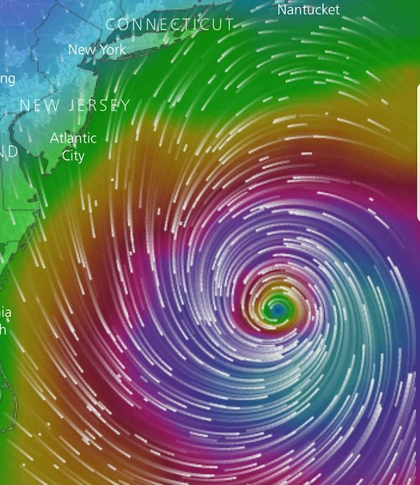
Hurricane Maria moves dangerously close to New York but stays away from land.
However, the forecasting models are simply projections. Hurricane Irma also was on track to possibly head out to sea until the massive storm shifted to the western coast of Florida. That all has people watching Maria very closely (Irma was a stronger storm, registering 185 mph winds.)
Still, the shift to the north looked even more pronounced on September 20 than it had in the previous days – in the favor of those living on the American east coast. For at least a day, some of them did show North Carolina especially in peril of a possible landfall, but that seems more remote now..
To see how the storm has shifted, here’s a spaghetti model from September 19:
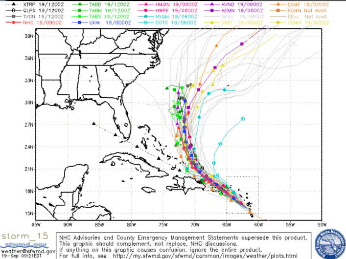
Spaghetti model for Hurricane Maria on September 19.
For comparison purposes, here’s the SFWMD map for Maria from September 18.
SFWMDMaria spaghetti plot for the evening of September 18.
In contrast, the National Hurricane Center uses a forecast cone model. Here’s the model for the evening of September 20. The path it’s charting closely resembles the path in the spaghetti models. It shows that no state in the east coast of the U.S. is in the cone of uncertainty.
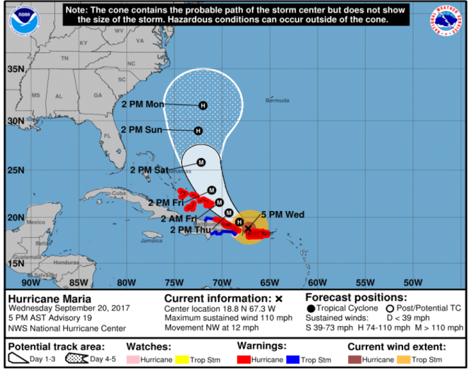
NHCHurricane Maria’s projected path on September 20 evening.
Here’s a look at the projected wind arrival times for Maria:
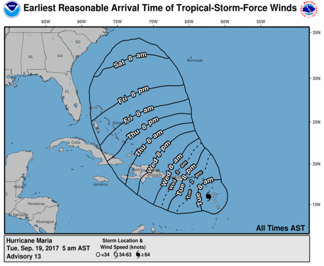
National Hurricane Center
On September 20, the National Hurricane Center released this update on Maria:
“An Air Force Reserve reconnaissance aircraft found that Maria’s center moved off the northwestern coast of Puerto Rico just before 1800 UTC, but the hurricane appears to have taken quite a hit from the high mountains of the island. The aircraft measured a maximum flight-level wind of 106 kt to the east of the center and SFMR surface winds as high as 91 kt. The initial intensity is therefore set to 95 kt. The central pressure has also risen considerably, and the latest report from the airplane is 957 mb.
Maria may have taken a temporary jog west-northwestward across Puerto Rico, likely due to topographic effects, but the longer-term motion remains northwestward, or 305/10 kt. Maria should maintain a northwestward motion for the next 36 hours while it remains on the southwestern periphery of a mid-level high over the western
Atlantic. After 36 hours, Maria is expected to turn northward between the high and a broad trough extending from Tropical Storm Jose southwestward into the Gulf of Mexico. The updated track guidance remains in excellent agreement on this scenario, and the overall guidance envelope has shifted a bit eastward on this cycle.
The new NHC forecast is therefore nudged a little east of the previous forecast toward the various consensus aids.
It may take some time for Maria’s structure to reorganize itself now that it is back over water. Although the intensity models are not all that enthusiastic about strengthening, the environment looks conducive for intensification, and the NHC forecast lies at the upper bound of the guidance, closest to the HWRF solution. It
would not be surprising, however, if Maria eventually strengthens more than shown here. Some weakening is expected by days 4 and 5 due to increased shear, as well as Maria possibly moving over the cold wake of Tropical Storm Jose to the east of the Carolinas.
We would like to thank the crew of the latest Air Force Reserve mission for their incredible service today. After beginning their mission this morning before the center first moved onshore, the crew went above and beyond, returning to Curacao to refuel, and then heading back to Puerto Rico to catch Maria’s center when it first moved back off the coast. The data collected by the crew was incredibly important for us to analyze Maria’s intensity and structure after moving across the island, and we are grateful for their effort.
KEY MESSAGES:
1. Maria’s core is moving away from the northwestern coast of Puerto Rico, and strong winds and storm surge flooding should subside through early Thursday. However, heavy rainfall is expected to continue, and catastrophic flash flooding is occurring on the island, especially in areas of mountainous terrain. Everyone in Puerto Rico should continue to follow advice from local officials to avoid these life-threatening flooding conditions.
2. A Hurricane Warning is in effect for the northern coast of the Dominican Republic, the Turks and Caicos Islands, and the southeastern Bahamas, where Maria is expected to bring dangerous wind, storm surge, and heavy rainfall.”