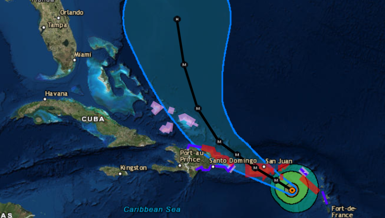
NHC Maria cone on September 19.
Hurricane Maria has been making people in Florida very nervous – not to mention those in Puerto Rico – because, in the early stages, her path has looked pretty similar to that of the monstrous Hurricane Irma.
Maria’s wind strength has increased also, with the storm registering 165 mph winds as of the evening of September 19 (Irma’s wind speeds ranged up to 185 mph).
All of this has a lot of people wanting to know where the storm is – right now. However, the models posted online can be outdated the second they are shared. There are multiple ways, though, that you can get real-time data and maps on Hurricane Maria’s path.

All of the forecast maps – spaghetti and cone and otherwise – are just projections. Hurricane Irma’s path switched to the west at the last minute.
All of that being said, here are some of the best Maria trackers that you can use to follow the storm’s path:
Google Crisis Response
The Google Crisis Response map has a real-time tracker for Hurricane Maria. You can see it here.
National Hurricane Center & National Weather Service
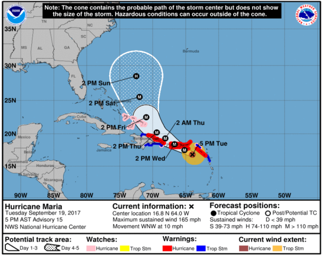
NHCHurricane Maria cone forecast for the evening of September 19.
The National Hurricane Center and the National Weather Service are go-to sites that the news media most heavily rely on. Indeed, many of the news stories are simply based on maps and data released, like clockwork, several times a day by these services. They also have a variety of real-time maps, such as satellite imagery. The National Hurricane Center tracks all of the active hurricanes and tropical storms, including Jose as well as Maria.
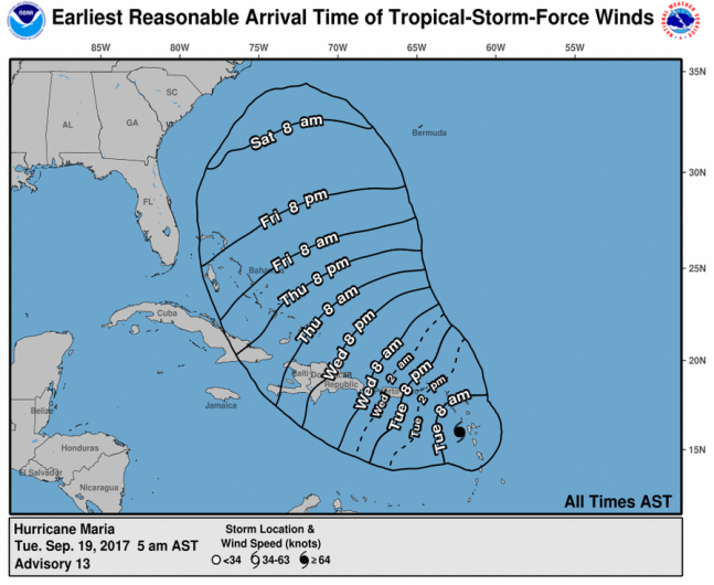
Here is the Center’s page for Hurricane Maria. You can track many different projections on the page for the storm, ranging from wind speeds to rainfall to projected arrival times. See the storm’s forecast advisory here.
National Hurricane Center
You can also search for any community in the U.S. in the National Weather Service page and get updated real-time maps for the weather in the area. For example, here’s Tampa. Just enter city, state or zip code in the top left box.
The Weather Channel & PBS
The Weather Channel has an updated tracker for Hurricane Maria.
PBS also has a real-time map to find Maria’s location.
NOAA
The National Oceanic and Atmospheric Administration has an updated map that tracks the paths of all hurricanes and tropical storms for 2017, including Tropical Storm Maria. The map currently has Jose and Lee on it also. You can even map the historical tracks of all hurricanes here.
See colorized infrared images of the storm that you can update with your cursor. Follow storm systems over the continental U.S. here. Track other 2017 storms here.
Cyclocane
Cyclocane has a lot of real-time maps including satellite and spaghetti models for Maria. The Cyclocane site will also give you data such as the storm’s current status.
Weather Underground
Weather Underground also offers a lot of real-time maps on Maria.
South Florida Waste Management District
This government site has a regularly updated spaghetti model of the storm’s path. See the map here.
UW-Madison & National Center for Atmospheric Research
NCAR’s Tropical Cyclone Guidance Project has a lot of real-time data and maps, including spaghetti models. See the Hurricane Maria page here.
The University of Wisconsin-Madison is also doing real-time tracking. Click on the yellow symbol for Maria to see more at this page.