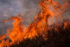
Creek Fire is located off Kagel Canyon Road near Sylmar in Los Angeles County, California. The brush fire broke out in the middle of the night and has burned through over 15,000 acres, according to the latest update from CAL Fire. The fire is currently 80 percent contained.
The blaze was first reported around 4 a.m local time on December 5 near Gold Creek and Little Tujunga Canyon roads. It started with 100 acres involved, but extremely high winds in the southern California area caused the fire to spread rapidly.
“Strong east, northeast winds are expected to continue through Wednesday evening, bringing smoke into the western portion of Los Angeles County. Air quality may reach unhealthy levels or higher in areas directly impacted by smoke, including west San Fernando Valley, east San Fernando Valley, southwest Los Angeles County Coastal and northwest Los Angeles County Coastal,” reports ABC7.
According to Jim Cantore of The Weather Channel, the fire is consuming “roughly a football field a second.”

“Firefighters are aggressively protecting homes in the Sylmar area, fire officials say. Additional resources are on the way,” according to NBC San Diego.
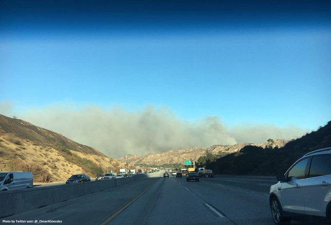
Below is a photo of the smoke in the area from December 5.
#CreekFire [update] off Kagel Canyon Rd., north of Lake View Terrace (Los Angeles County) per @LACoFDPIO is now 2,500 acres.
“The Los Angeles County Sheriff’s Department was ordering evacuations in unincorporated areas. The Los Angeles Police Department was handling evacuations in parts of Sylmar and Lake View Terrace,” reports the Los Angeles Times.
Mandatory evacuations were ordered in Kagel Canyon, the trailer park in Lopez Canyon, Arroyo Street north of the 210 Freeway, the mobile home park at top of Maclay Street, Pacoima Wash west of Sayre Street, as well as Eldridge and Hubbard streets. There are voluntary evacuations in the following areas: East of Veterans Park to Pacoima Canyon, between Sayre and Polk streets, North of the 210 Freeway, between Polk and Bledsoe streets, between Bledsoe and Roxford streets, between Roxford Street and Glenoaks Boulevard, between Glenoaks and Filbert street, and Filbert to the interchange of the 5 and 14 freeways.
For those who have left their homes, evacuation centers have been set up at the Sylmar Recreation Center, 13109 Borden Ave., and Sunland Senior Center, 8640 Fenwick Street, both of which accept small animals.
Below is additional information for residents with larger animals, such as horses.
LARGE ANIMALS & 🐎 HORSE EVACUATIONS:
Pierce College
6201 Winnetka
Woodland Hills 91371
(818) 719-6404
SMALL ANIMAL 🐶🐱 SHELTERS
W Valley Shelter
20655 Plummer
Chatsworth 91311
(888) 452-7381
E Valley Shelter
14409 Vanowen
Van Nuys 91405
(888) 452-7381
On Tuesday, December 5, a smoke advisory was released by the South Coast Air Quality Management District.
“Air quality may reach Unhealthy levels or higher in areas directly impacted by smoke. Areas of direct smoke impacts and Unhealthful air quality include portions of: West San Fernando Valley (Forecast Area 6), East San Fernando Valley (Forecast Area 7), and Northwest Los Angeles County Coastal (Forecast Area 2).”
Firefighters have also battling the Thomas Fire, located in Ventura County, which has spread to well over 31,000 acres.
The National Weather Service has issued “red flag warnings” for Los Angeles and Ventura Counties through Saturday.
“The strongest and longest duration Santa Ana wind event we have seen so far this season will continue through at least Saturday. Damaging wind gusts of 45 to 65 mph will continue today across wind prone areas of Los Angeles and Ventura counties, with slightly weaker winds tonight into Saturday. These Santa Ana winds combined with humidities in the teens and single digits, along with very dry fuels, will continue to bring an extended period of critical fire weather conditions to much of Los Angeles and Ventura Counties. If fire ignitions occur, there is a high likelihood of very rapid fire spread, long range spotting, and extreme fire behavior. Other potential impacts today include downed trees and power lines, blowing dust and debris, as well as power outages,” read the warning.