National Hurricane Center
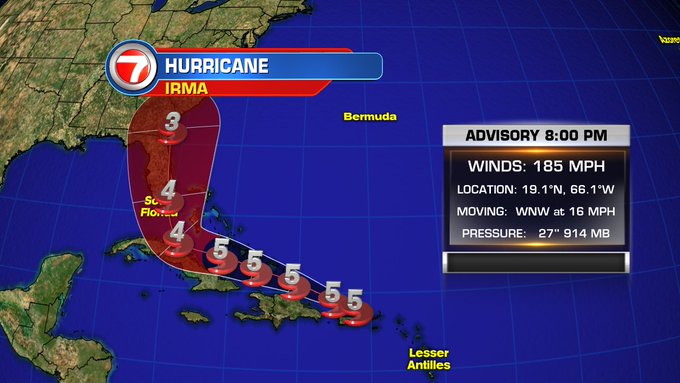
Hurricane Irma is a Category 5 packing 185 mph winds and could be one of the biggest storms in recent history, but it’s exact impact on Fort Lauderdale is still being determined. However, because there’s a good chance they will be affected, Broward County has already issued a mandatory evacuation order for low-lying areas and mobile homes, staring Thursday
Although Irma may not make a possible landfall on the U.S. coast until this weekend, many people in parts of Florida are already evacuating. The hurricane has already left extensive destruction in its wake, as it tore through areas like the tiny island of Barbuda, which was left with 90 percent of its structures damaged. Now it’s heading to the Dominican Republic and the Bahamas, moving at about 16 mph.
Here’s everything we know so far about the hurricane’s potential impact in Fort Lauderdale.
Hurricane Irma Path Updates

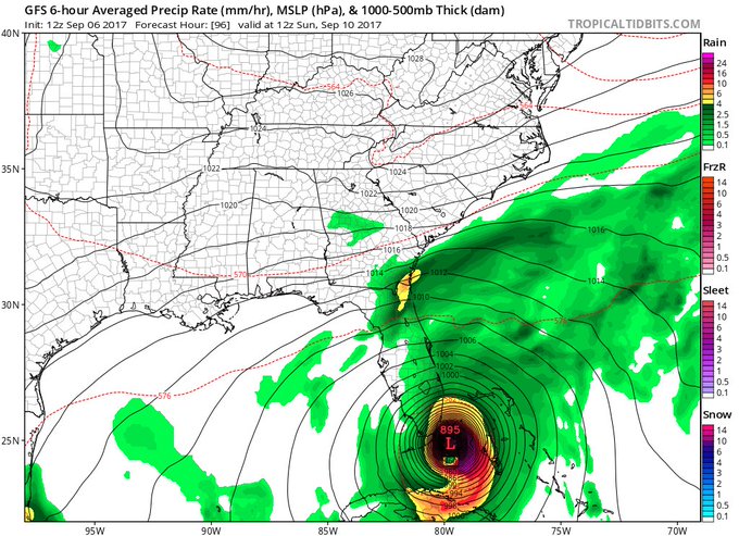
12z GFS not a good look for SE Florida…certainly more corrections coming, but models seem to be zeroing in.
At 5 p.m., the National Hurricane Center in Miami released its latest projection for Hurricane Irma.
Here are the latest Key Messages for #Irma advisory 31 t.co/tW4KeGdBFb
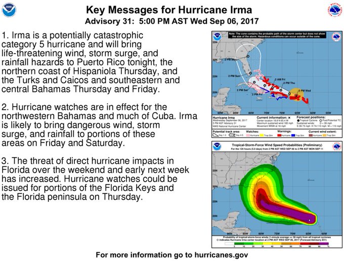
Unfortunately, the latest 5 pm advisory stated:
The threat of direct hurricane impacts in Florida over the weekend and early next week has increased. Hurricane watches could be issued for portions of the Florida Keys and the Florida peninsula on Thursday.”
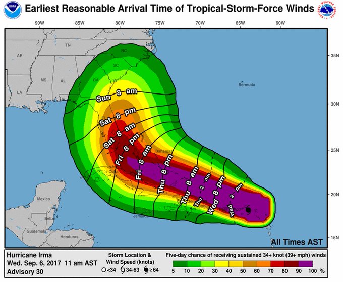
And here are the latest estimates on when to expect tropical storm force winds:
9/6 2pm: Latest estimates of when tropical-storm-force winds could arrive & are most likely to arrive with #Irma t.co/tW4KeGdBFb

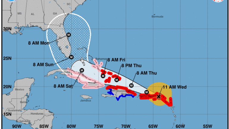
Irma is located at 18.8 N and 65.4 W as of 5 p.m., the National Hurricane Center reported, about 55 miles ENE of San Juan Puerto Rico, with maximum sustained winds of 185 mph, moving WNW at 16 mph.
Here is the latest forecast track on #Irma
National Hurricane Center 7 p.m. update
Evacuations in Broward County
A mandatory evacuation has been issued for all residents in Broward County living east of Federal Highway (U.S. Route 1) and in low-lying areas, starting noon on Thursday, ABC 10 reported.
You should know your evacuation zone in case additional mandatory evacuations are issued. To see if you’re in the evacuation zone, you can click here to find a larger PDF of the evacuation zone map.
Broward County Mayor Barbara Sharief said in a press conference on Tuesday:
If you live in an evacuation zone, determine when and where you will evacuate to. Going to stay with family outside the evacuation zone is the best choice since shelters only provide for vacant needs.”
If you’re going to a shelter, make sure you have items to keep you comfortable, like bedding, snacks, water, and medicine. If you take a pet to a pet-friendly shelter, register it online first.
Here’s a list of general population shelters in Broward County:
Coconut Creek Lyons Creek Middle School
4333 Sol Press Blvd.
Coconut Creek, FL 33073
Coconut Creek Monarch High School
5050 Wiles Rd.
Coconut Creek, FL 33073
Coral Springs Coral Glades High School
2700 Sportsplex Dr.
Coral Springs, FL 33065
Davie Fox Trail Elementary School
1250 Nob Hill Rd.
Davie, FL 33324
Fort Lauderdale Rock Island Elementary/
Atlantic Technical (Arthur Ashe)
1701 N.W. 23rd Ave.
Fort Lauderdale, FL 33311
Pembroke Park Watkins Elementary School
3520 S.W. 52nd Ave.
Pembroke Park, FL 33023
Lauderdale Lakes Park Lakes Elementary School
3925 N. State Rd. 7
Lauderdale Lakes, FL 33319
Miramar New Renaissance Middle School
10701 Miramar Blvd.
Miramar, FL 33025
Miramar Everglades High School
17100 SW 48TH CT
Miramar, FL 33027
Pembroke Pines Silver Trail Middle School
18300 Sheridan St.
Pembroke Pines, FL 33331
Pembroke Pines West Broward High School
500 NW 209 Ave.
Pembroke Pines, FL 33029
Plantation Plantation Elementary School
651 N.W. 42nd Ave.
Plantation, FL 33317
Pompano Beach Pompano Beach High School
600 N.E. 13 Ave.
Pompano Beach, FL 33060
Weston Falcon Cove Middle School
4251 Bonaventure Blvd.
Weston, FL 33332
A pet friendly shelter is located at Millennium Middle School at 5803 NW 94th Ave. in Tamarac, Florida, but pre-registration is required. Service animals are allowed in general population shelters as long as they meet federal requirements.
Emergency Preparation in Fort Lauderdale & Broward County
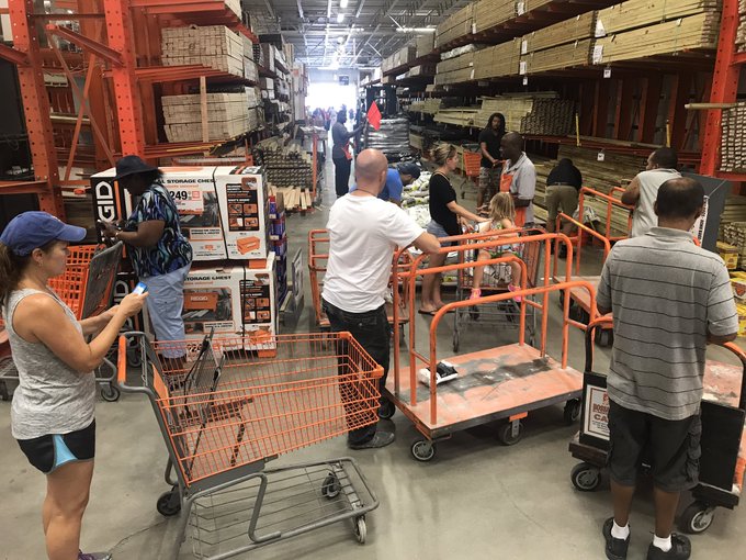
A truck of sand arrived at Fort Lauderdale @HomeDepot. Line is growing, pallets emptying as they are unwraped. #HurricanePrep #HurricaneIrma
Governor Rick Scott has already declared a State of Emergency to prepare for the storm in Florida. The emergency hotline for residents in Broward County is now open. Residents can call 311 or 954-831-4000.
Residents should be finalizing their emergency plans and make sure they’re stocked up on emergency supplies, because they’re getting tougher to find. You should have enough food and water to last three to five days. If you’re using a generator, keep it outside in a well-ventilated area.
But don’t trim your trees anymore, because items left on the side of the road could cause damage when wind increases. If you live in an evacuation zone, figure out now where you’ll evacuate to, such as staying with friends or family outside of the zone.
Classes have already been cancelled for Thursday and Friday.
On Wednesday Sharief said:
Irma is a dangerous storm and all residents should take it seriously. Everyone should be finalizing their plans and completing their preparations today and tomorrow.”
Here’s the current long range forecast for Fort Lauderdale, according to the National Weather Service. This could change as the hurricane’s path becomes more predictable.
Floridians are asked to visit FloridaDisaster.org/GetAPlan to plan ahead for the storm.
If you’re in Broward County and want to stay updated, text ALERTBROWARD to 888-777.
If you experience a power outage, notify Florida Power & Light at 800-468-8243 or at FPL.com.