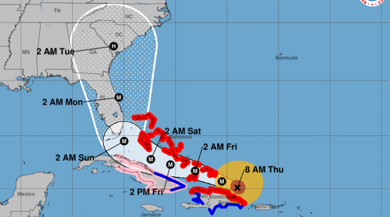
NOAA/National Hurricane Center NOAA's Irma projection from 8:00 a.m. ET.
The first hurricane watches for Hurricane Irma have been issued for South Florida and the Florida Keys in the latest update from the National Hurricane Center and the National Oceanic and Atmospheric Administration. The storm remains a category 5 hurricane, with maximum sustained winds at 175 mph. It is 75 miles east-northeast of Puerto Plata, Dominican Republic.
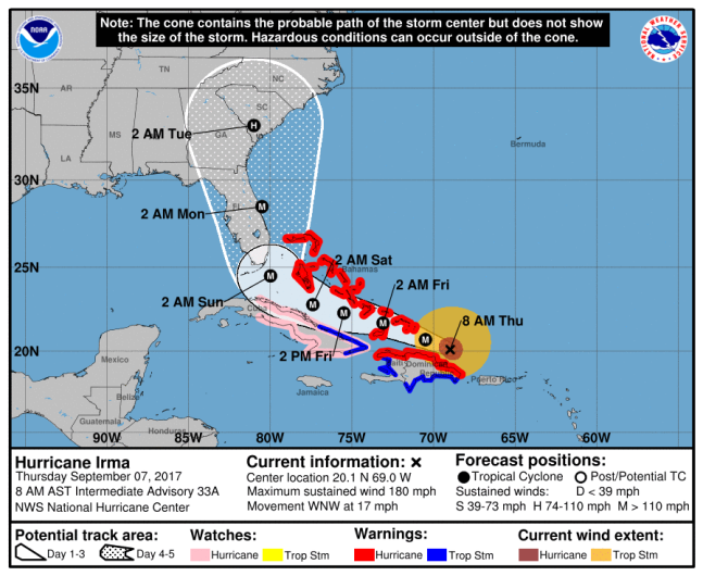
NOAA/NHCNOAA’s Irma projection from 8:00 a.m. ET.
The NHC issued Hurricane Watches for “Jupiter Inlet southward around the Florida peninsula to Bonita Beach,” the Florida Keys, Lake Okeechobee and Florida Bay. Storm Surge Watches were issued for “Jupiter Inlet southward around the Florida peninsula to Bonita Beach” and the Florida Keys. The cities covered by the watch include Naples, Key West, Key Largo, Miami and West Palm Beach.
A hurricane watch means that hurricane conditions are possible in the area and are issued 48 hours in advance “before the anticipated first occurrence of tropical-storm-force winds, conditions that make outside preparations difficult or dangerous,” according to the NHC.
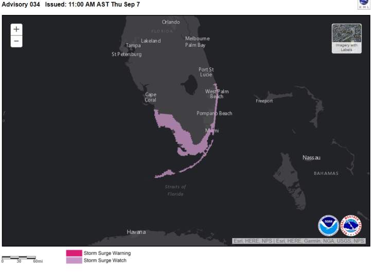
NOAA/NHCThe pink area is under a Storm Surge Watch.
A Storm Surge Watch “means there is a possibility of life-threatening inundation, from rising water moving inland from the coastline, in the indicated locations during the next 48 hours.”
A Hurricane Watch is different from a Hurricane Warning. A hurricane warning means that hurricane conditions are expected within the area and are issued 36 hours before hurricane or tropical storm-force winds reach the area. They are issued 36 hours in advance and, by then, residents should be prepared to evacuate the area as instructed by local officials.
As of the 11:00 a.m. NHC update, Hurricane Warnings are in effect for “Dominican Republic from Cabo Engano to the northern border with Haiti,” “Haiti from the northern border with the Dominican Republic to Le Mole St. Nicholas,” Southeastern Bahamas and the Turks and Caicos Islands, Central Bahamas and Northwestern Bahamas.