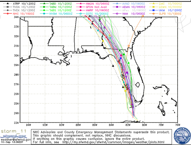
South Florida Waste Management District Sunday spaghetti model.
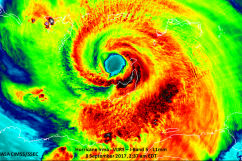
Hurricane Irma made its second landfall along Marco Island and was five miles from Naples at 5 p.m. Sunday.
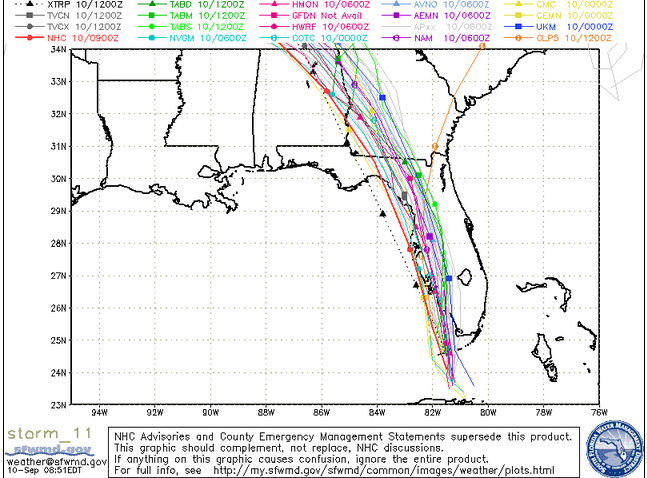
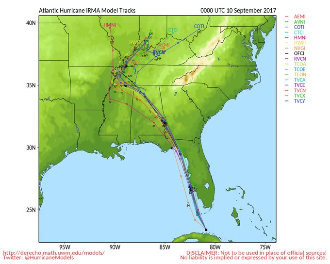
The recent spaghetti models from the afternoon of September 10 show the southwestern danger and path. The South Florida Waste Management District releases updated spaghetti models on its page.
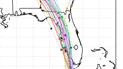
Here’s the plot for Sunday afternoon:
Sunday afternoon spaghetti model.
You can also see other Sunday spaghetti models from the National Center for Atmospheric Research here and here, and from Cyclocane, which has real-time spaghetti models here and other hurricane real-time trackers, like radar, here.
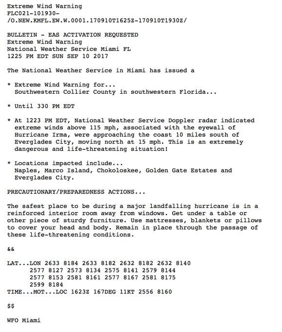
The storm made its first landfall in the U.S. on Cudjoe Key at 9:10 a.m. “The National Hurricane Center is tracking Irma’s position roughly 80 miles (125 km) south-southeast of Naples, and about 115 miles (180 km) south-southeast of Fort Myers. Irma is now traveling towards the north at 9 mph (15 km/h), with sustained wind speeds of up to 130 mph (215 km/h),” according to the 11 a.m. updates on Sunday. Extreme winds were approaching the southwestern coast 10 miles south of Everglades City in the afternoon. According to CNN, “the hurricane’s eyewall will move to Marco Island around 1:45 p.m. After that, it’ll move toward Naples.” At 2 p.m., CNN reported it would strike Naples in less than an hour.
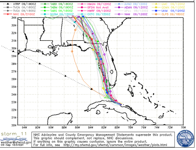
Here’s the Sunday morning plot for comparison purposes from the SFWMD:
Central Florida Waste Management DistrictSunday morning spaghetti model.
That’s pretty consistent from the evening before. The key difference: The plots are affecting more of the southwestern Florida peninsula, and it’s a little less tight.
South Florida Waste Management DistrictSaturday evening spaghetti model.
It’s was believed for at least a day that the hurricane will land in southwestern Florida in the area between Sarasota and Naples, with areas most in threat being Marco Island,the Fort Myers area, Port Charlotte, and possibly even Tampa (which is next in the path at any rate). Spaghetti plots for Sunday make that point.
In addition to spaghetti models, there are many real-time trackers that offer satellite maps, radar, and other methods to track Hurricane Irma’s path in real time. You can see a roundup of the best sites to do so here.
Tracking Irma – SPAGHETTI PLOTS t.co/LSlD3Wi4j9
Irma spaghetti models #IrmaHurricane2017
TODAY’S TRACK 9-10-17 Here is the latest map for the Hurricane. EVANSVILLE area will see the remnants of the Hurricane IRMA on Thursday.

The National Hurricane Center doesn’t use spaghetti models. It uses forecast cones. Here’s the Sunday cone:
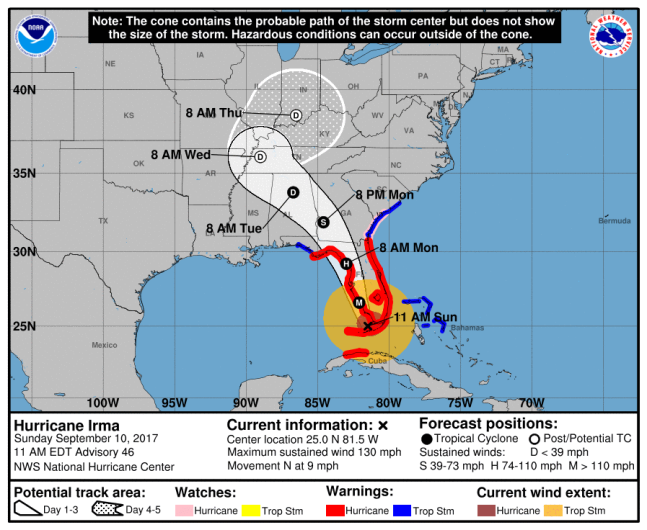
NOAA/NHCThe National Hurricane Center’s 11:00 a.m. ET Hurricane Irma projection.
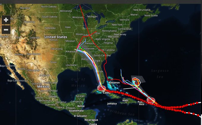
Check out this way of visualizing the hurricane’s path:
NASA satellite images show Hurricane #Irma‘s path from Aug. 30-Sept. 9 with Hurricane #Jose right behind it. #HurrcaneIrma #JoseHurricane
PBS has an updated map with the storm’s path also.
The news of the first landfall was announced by the National Hurricane Center, which wrote, “Hurricane #Irma makes landfall at Cudjoe Key in the lower Florida Keys.”
Three keys – Cudjoe, Big Pine Key and Summerland Key – were in the eye of the hurricane on Sunday morning.
Big Pine Key, Summerland Key and Cudjoe Key in the eye of Hurricane #Irma. Do not venture outside t.co/tW4KeGdBFb @NWS @NOAA
See more trackers here: