National Weather Service Though Hurricane Florence was downgraded to a category 2 hurricane, it's still caused storm surges up to 10 feet in some areas, with the worst of the flooding still expected to come.
Though Hurricane Florence has been downgraded to a category 2 storm over the last 24 hours, it’s still predicted to cause significant damage, particularly in relation to flooding along the coast and further inland.
For now, the city of Myrtle Beach is likely to get significant rainfall from Hurricane Florence, as well as major storm surges.
Here’s what you need to know.
Myrtle Beach Is Predicted to Get Anywhere From 10-20 Inches of Rain
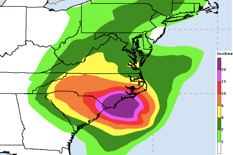
National Weather Service
According to the National Weather Service, Myrtle Beach is likely to receive significant rainfall from Hurricane Florence starting Thursday. Depending on Hurricane Florence’s path, Myrtle Beach will likely receive anywhere from 10-20 inches of rain, which doesn’t include flooding risk from storm surges, too.
Accuweather reports that residents of the Carolina coastline will likely be “bombarded” with rain and heavy wind from Thursday to Saturday. Though NWS estimates upwards of 20 inches of rainfall along the coastline, Accuweather is estimating closer to 40 inches, which could lead to catastrophic levels of flooding from the coastline inland.

Myrtle Beach is currently classified under “moderate” risk of flooding, according to the NWS.
Myrtle Beach Should Expect Up to Nine Feet of Storm Surges Along the Coastline
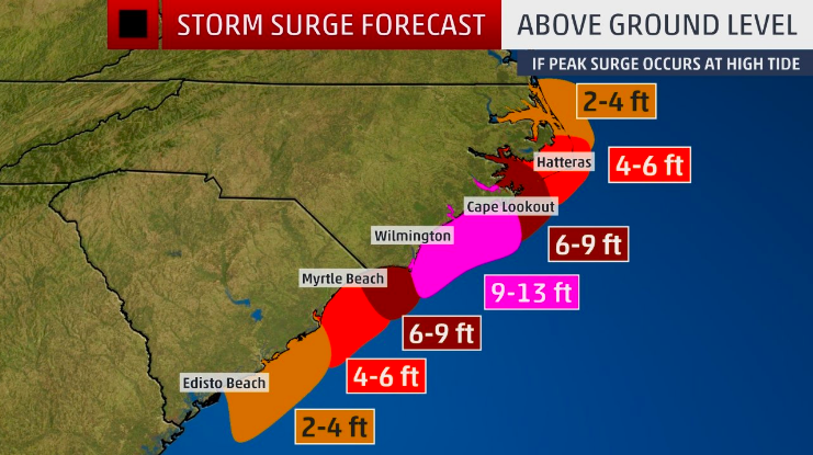
National Hurricane CenterMyrtle Beach is likely to experience high storm surges of up to nine feet from Hurricane Florence.
According to the National Hurricane Center, Myrtle Beach is likely to receive anywhere from four to nine feet of storm surges from Hurricane Florence, depending upon the path of the hurricane.
Weather.com says of the expected storm surges: “A destructive storm surge will accompany the eye coming ashore sometime from Thursday night into Friday or Saturday, and coastal flooding may persist through multiple high tide cycles into this weekend east of the center of Florence. Large, battering waves will ride atop this surge. All evacuation orders from local officials should be followed because of this dangerous threat. Significant beach erosion is also likely on the southeastern U.S. coast. Elevated water levels may persist for some time after landfall in areas where onshore winds persist.”
The Weather Channel estimates that storm surges of nine feet could cause floods that are so high they might cover the entire first floor of buildings.
Weather Forecast for Myrtle Beach For the Next Week
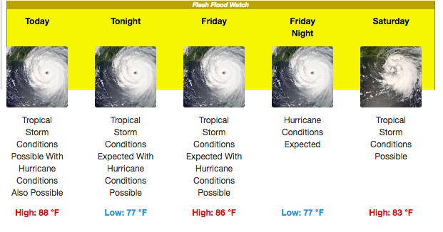
According to the NWS, here’s the weather forecast for the next week: