Hurricane Dorian will be arriving in Florida just in time for the Labor Day holiday. At the time Dorian arrives on Florida’s east coast, however, the storm is expected to be nothing more than a tropical depression — that is, if everything goes as currently predicted.
Dorian is approximately 95 miles east-southeast of Barbados. The National Hurricane Center issued a hurricane watch for St. Lucia and a tropical storm warning for Barbados, St. Vincent, and the Grenadines. A tropical storm watch is in effect for Dominica, Martinique, and Grenada.
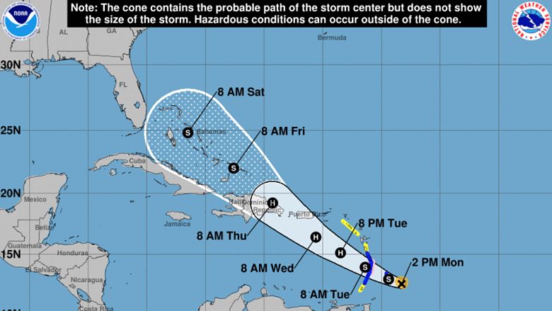
Dorian is considered a small storm which is both good and bad. While it likely won’t intensify to a raging Category 4, for example, it’s a bit harder to track as it moves west through the Caribbean.
The latest computer models — both the Euro and the GFS — show Dorian skirting south of Puerto Rico and making landfall in Hispaniola. If this happens, Dorian is expected to lose steam before reaching the Bahamas. Despite the warm water, there is a dry air mass that will make it challenging for the storm to pick up steam before arriving in the United States.
So, what does that mean for Florida? Will Dorian wreak havoc on the Sunshine State this weekend?
Here’s what you need to know:
Dorian Is Expected to Make Landfall as a Tropical Depression in Florida on Sunday
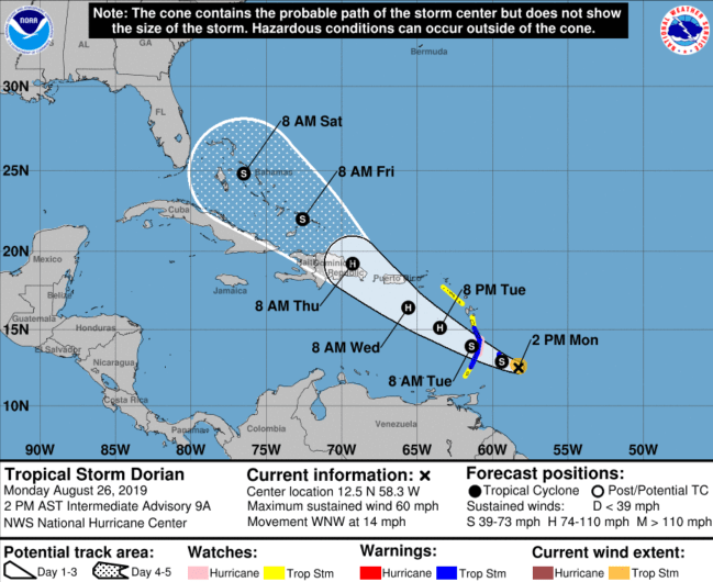
Regardless of what kind of shape Dorian is in, the storm is expected to arrive in Florida on Sunday, September 1. According to the latest model runs, Dorian will arrive in Florida, somewhere in Brevard County as a tropical depression.
A tropical depression is defined as a low-pressure system that produces thunderstorms with elevated winds. It is elevated to a tropical storm when the winds increase.
“A tropical depression forms when a low-pressure area is accompanied by thunderstorms that produce a circular wind flow with maximum sustained winds below 39 mph. An upgrade to a tropical storm occurs when cyclonic circulation becomes more organized and maximum sustained winds gust between 39 mph and 73 mph,” NASA reports.
The Forecast Could Change in a Blink if Dorian Skirts Hispaniola
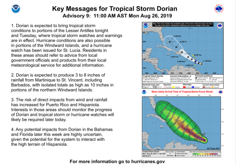
Dorian’s track is of the utmost importance when it comes to the impact the storm will have on Florida. As of Monday afternoon, all signs point to a rainy, stormy Sunday for the east coast as the storm pushes through and continues to lose steam as it heads toward Tallahassee. However, a bit of a shift could mean something else entirely.
“The ENTIRE forecast hinges on how much interaction occurs with Hispaniola. Less would be a stronger storm. More would be weaker. Until that point, model runs are practically useless,” Tampa-based meteorologist Denis Phillips wrote in a Facebook update.
“Bottom line, at this point, shear, dry air, and land will inhibit development. After passing the islands, we’ll see how it plays out,” Phillips added. He cautions residents to have a plan in place but believes it’s “highly unlikely” that Dorian turns into a major event.
READ NEXT: Will Hurricane Dorian Hit Disney World?