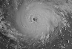
National Weather Service Hurricane Irma on September 5.
Hurricane Irma became a dangerous Category 5 storm with wind speeds of 175 miles per hour. The hurricane was headed toward Florida, but what are the chances it could hit Port Lucie?
(Note: You can read an updated post for September 7 for Port St. Lucie here.)
Irma was headed toward Puerto Rico and the Virgin Islands on September 5. Tropical Storm conditions are possible in St. Lucie on Saturday, according to September 5 weather forecasts for the area, although there was not a hurricane watch or warning. Right now, the storm is predicted to cut a swath through southern Florida, including Miami and Key West. The closest approach to central Florida from the storm is expected to come on Sunday. The Florida governor has declared a state of emergency.

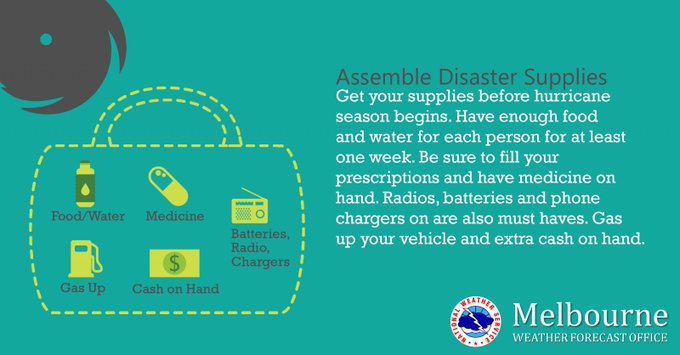
Confidence increasing that major hurricane #Irma will have at least some impact on Florida. Don’t wait until the last minute to prepare!

Track the path of Hurricane Irma here. See updated radar for the St. Lucie area here (it’s tracked out of the Melbourne office of the National Weather Service.) See an infrared satellite map here. See the hourly forecast data here.
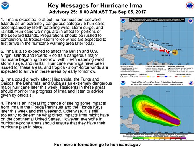
Key Messages on Category 5 Hurricane #Irma for 8am EDT
The hazardous weather outlook for east central Florida, including Port St. Lucie, as of September 5 reads:
For September 5: “Isolated lightning storms are forecast to develop near the coast as the Atlantic sea breeze pushes inland early this afternoon. Storm coverage will increase over the interior counties from mid to late afternoon as the sea breeze begins to interact with other boundaries. A few storms could become strong with winds gusts of 40 to 50 mph, frequent cloud to ground lightning strikes, and very heavy rainfall the primary weather hazards. Locally heavy rain in slow moving storms will be possible this afternoon, especially across the inland counties. Rainfall amounts between 2 and 3 inches in a short time period will produce ponding of water on roadways and flooding in poor drainage areas. A long period swell will maintain a moderate risk for dangerous rip currents at area beaches today. Check with local beach patrol before entering the water and never swim alone!”
The outlook continues: “DAYS TWO THROUGH SEVEN…WEDNESDAY THROUGH MONDAY. Shower and thunderstorm chances will increase to above normal from Wednesday onward as an early season cool front sags into north Florida and stalls. The forecast for this weekend remains somewhat uncertain as Major Hurricane Irma moves into the Florida Straits and makes its closest approach to central Florida, probably around Sunday. While it is still too early to be specific about any direct impacts that Irma will have on east central Florida, there is an increasing likelihood of as least some impact from the system. Increasing rain chances and increasingly windy conditions are likely this weekend, and boating and surf conditions are expected to become increasingly hazardous by late week, and dangerous by this weekend.”
The storm remains unpredictable.
2pm Still too early to be specific about direct impacts that Irma might have on EC Florida, but it’s never too early to have your supplies.
“Hurricane Center and National Weather Service forecasters warned it’s too soon to tell what Irma’s impacts could be in Florida or other hurricane-prone areas of the United States,” Gainesville.com reported. “Forecasters must wait to see if Irma takes a predicted turn to the north as it travels around a high-pressure ridge over the Atlantic Ocean and see how the ridge and hurricane interact with a trough moving across the U.S.”
8 am Special Advisory: #Irma is now a category 5 #hurricane with maximum sustained winds of 175 mph (280 km/h) More: t.co/tW4KeGdBFb
See the weather forecast page for St. Lucie here. Again, be aware that St. Lucie’s weather is tracked out of the Melbourne, Florida office of the National Weather Service.
National Weather Service
Here’s the projected path of the storm as of September 5:
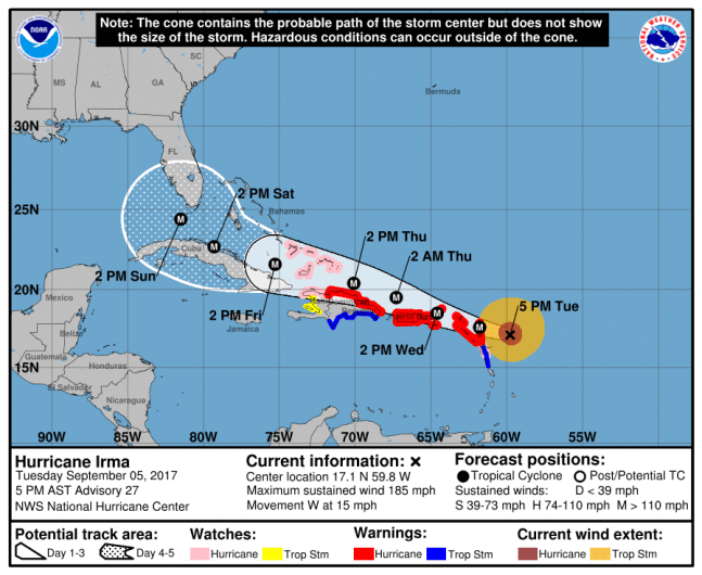
NOAAThe NHC’s projection for Hurricane Irma as of Tuesday at 5 p.m. AST.
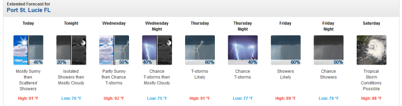
The extended forecast for the Port St. Lucie area is as follows:
Today (September 5)
“Scattered showers and thunderstorms after noon. Partly sunny, with a high near 91. Heat index values as high as 103. East wind 5 to 10 mph. Chance of precipitation is 40%.”
Tonight
“Isolated showers before 11pm. Mostly cloudy, with a low around 76. East southeast wind around 5 mph. Chance of precipitation is 20%.”
Wednesday
“A 50 percent chance of showers and thunderstorms after noon. Mostly cloudy, with a high near 92. Heat index values as high as 105. Calm wind becoming east southeast around 5 mph in the afternoon. New rainfall amounts between a tenth and quarter of an inch, except higher amounts possible in thunderstorms.”
Wednesday Night
“A 40 percent chance of showers and thunderstorms before midnight. Mostly cloudy, with a low around 75. East southeast wind around 5 mph.”
Thursday
“Showers and thunderstorms likely after 11am. Mostly cloudy, with a high near 91. Light north northeast wind becoming east northeast 5 to 10 mph in the afternoon. Chance of precipitation is 60%.”
Thursday Night
“A 40 percent chance of showers and thunderstorms. Mostly cloudy, with a low around 77. East northeast wind 5 to 10 mph.”
Friday
“Showers likely and possibly a thunderstorm. Mostly cloudy, with a high near 89. Northeast wind 10 to 15 mph, with gusts as high as 20 mph. Chance of precipitation is 60%.”
Friday Night
“A 50 percent chance of showers and thunderstorms. Mostly cloudy, with a low around 78. Northeast wind around 15 mph, with gusts as high as 25 mph.”
Saturday
“Tropical storm conditions possible. Showers likely and possibly a thunderstorm. Mostly cloudy, with a high near 88. Chance of precipitation is 60%.”
Saturday Night
“Showers likely and possibly a thunderstorm. Cloudy, with a low around 78. Windy, with an east northeast wind 25 to 30 mph, with gusts as high as 40 mph. Chance of precipitation is 70%.”
Sunday
“Showers likely and possibly a thunderstorm. Cloudy, with a high near 87. Windy, with an east northeast wind 35 to 40 mph, with gusts as high as 55 mph. Chance of precipitation is 70%.”
Sunday Night
“Showers likely and possibly a thunderstorm. Cloudy, with a low around 76. Windy, with an east wind around 40 mph becoming southwest after midnight. Winds could gust as high as 55 mph. Chance of precipitation is 70%.”
Monday
“Showers likely and possibly a thunderstorm. Cloudy, with a high near 85. Windy, with a west southwest wind 30 to 35 mph, with gusts as high as 45 mph. Chance of precipitation is 60%.”