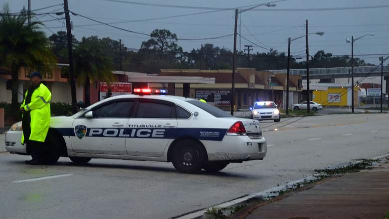
Getty Titusville during Hurricane Matthew in October 2016.
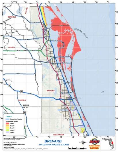
Brevard County, which includes Titusville and Melbourne, has issued a mandatory evacuation for parts of the county because of Hurricane Irma. Residents in mainland low-lying areas along the Indian River Lagoon, as well as those in Merritt Island are under a mandatory evacuation. It’s important for residents of the county to get familiar with the evacuation zones and list of shelters before the storm reaches Florida.
In addition to the maps below, click here to go to FloridaDisaster.org and type in your address. You can also call the Brevard County Information Hotline at 211.

Florida Division of Emergency ManagementThe Brevard County evacuation zone map. You can see a larger version below.
WFTV reports that the mandatory evacuation order specifically covers Evacuation Zone A. There are five evacuation zones in Brevard.
Brevard Evac Map by Daniel S Levine on Scribd
“Safety is our top priority, and we prepare for these types of situations,” Matthew Gerrell, vice president of marketing and communications, said in a statement. “As we continue to monitor Hurricane Irma, Health First is taking all of the necessary safety precautions. With Cape Canaveral Hospital being located on a barrier island, we felt the evacuation was needed to ensure the safety of our patients.”
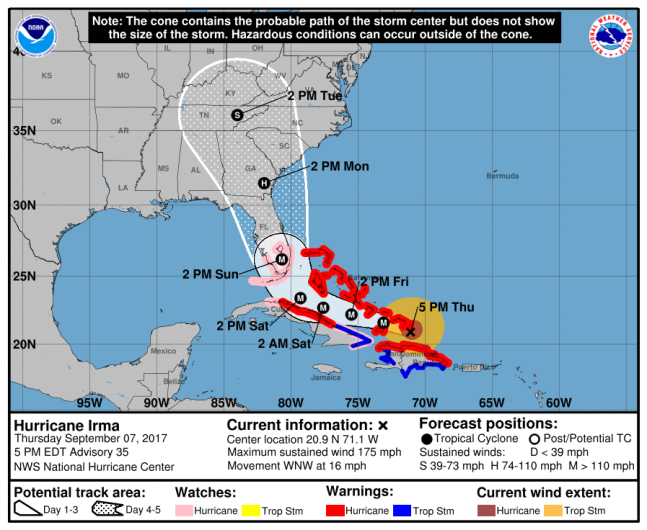
The 5:00 p.m. ET public advisory from the National Hurricane Center in Miami reports that Hurricane Irma is still a Category 5, with maximum sustained winds at 175 mph. It is only 40 miles south of Grand Turk Island. Hurricane watches have been issued for Jupiter and points south, including the Florida Keys.

NOAA/NHCHurricane Irma forecast at 5 p.m. Et
All 67 Florida counties have been under a State of Emergency since Monday. Brevard is under a local state of emergency. Governor Rick Scott has already activated 4,000 members of the Florida National Guard and plans to have 7,000 members activated by Friday.
The 12 general population shelters in Brevard County will open at 3 p.m. on Friday. There are also four pet-friendly shelters. Residents with special needs can call 211 to register. Brevard has also cancelled school for Thursday and Friday.
The list of locations where residents can pick up sandbags is available at BrevardFL.gov.
Here is the full list of shelters in Brevard County:
General Population
Apollo Elementary School, 3085 Knox McRae Dr., Titusville
Imperial Estates Elementary School, 900 Imperial Estates Lane, Titusville
Space Coast Junior/Senior High, 6150 Banyan Street, Port St John
Walter Butler Community Center at Bernice Jackson Park, 4201 US Highway 1, Cocoa
Manatee Elementary School, 3425 Viera Blvd., Viera
Sherwood Elementary School, 2541 Post Road, Melbourne
Melbourne High School, 74 Bulldog Blvd., Melbourne
Meadowlane Intermediate Elementary, 2700 Wingate Blvd., West Melbourne
Heritage High School 2351 Malabar Rd., Palm Bay
Bayside High School, 1901 DeGroodt Rd. S.W. Palm Bay
South Mainland Community Center, 3700 Allen Ave., Micco
Pet Friendly
Port St. John Community Center, 6650 Corto Road, Port St. John
Viera Regional Community Center, 2300 Judge Fran Jamieson Way, Viera
Wickham Park Community Center, 2815 Leisure Way, Melbourne
Ted Whitlock Community Center at Fred Poppe Regional Park, 1951 Malabar Rd NW, Palm Bay

