Go to main menu
Go to search form
Heavy
Sports
Alerts
Hi,
Subscriber
Search
Sports
News, stats, rumors, predictions and roster moves around the NFL, NBA, MLB, NHL and more.
More From Sports
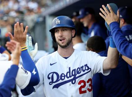
Dodgers Star Kyle Tucker Optimistic After Leaving Game With Back Spasms
22 seconds ago
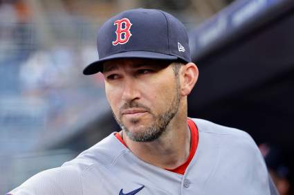
Red Sox Chad Tracy Attempts to Explain Blown Lead to Rockies, ‘Not Much to Say’
7 minutes ago
Chiefs, Dolphins Receive Strong Take on Bills’ Joshua Palmer
7 minutes ago
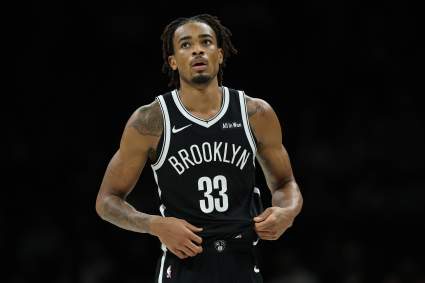
Chicago Bulls Fans React To Nic Claxton Trade
13 minutes ago
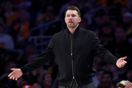
Lakers Lose Another Luka Doncic-Preferred Center in Sudden Trade Twist
5 minutes ago
List of Records Broken by Lionel Messi in Argentina’s Win vs Austria
32 minutes ago
Red Sox Chad Tracy Explains Sending Payton Tolle, Connelly Early Home Early
34 minutes ago
Joe Rogan Comments on Illegal Strikes in Pereira vs. Gane
35 minutes ago
Bulls Acquire Premier Shot-Blocker In Blockbuster 3-Team Trade
33 minutes ago
Phil Mickelson Faces Harsh Career Warning as Controversy Deepens
58 minutes ago
Lakers’ Austin Reaves Path Clears After Blockbuster NBA Trade
52 minutes ago
Minnesota Twins Star Joe Ryan Scratched Amid Trade Speculation
1 hour ago
Dave Roberts Comments on Dalton Rushing/Kyle Tucker Injuries After Dodgers-Twins Game
47 minutes ago
Taylor Swift Slams Door on Travis Kelce Wedding Invite For A-List Pal: Report
1 hour ago
New York Knicks Get Final Word on Julius Randle Trade After NBA Deal
1 hour ago
Atlanta Braves Announce Injury Update On 10-Year MLB Player
35 minutes ago
Falcons $3 Million Defender Called Team’s ‘Biggest Surprise’
1 hour ago
Nets Use Cap Space Advantage to Acquire Julius Randle
1 hour ago
Bills TE Dalton Kincaid Gets Good News After Troubling Injury Update
2 hours ago
Seahawks Land Intriguing Message on Giants’ Kayvon Thibodeaux
2 hours ago
BREAKING: NBA World Reacts To Minnesota Timberwolves Trading Julius Randle
25 minutes ago
Justin Gaethje’s Coach Noticed Why Ilia Topuria ‘Gets Super Flat’
2 hours ago
Celtics Now ‘Front-Runners’ in Giannis Antetokounmpo Sweepstakes: Insider
2 hours ago
Jordan World Cup Squad 2026: All 26 Players And Their Clubs
2 hours ago
New York Yankees Player Suffers Injury During Tigers Series
31 minutes ago
Ex-Seattle Seahawks QB Geno Smith Gets Police Investigation Update: Report
2 hours ago
Oilers Among Teams Linked to Canucks $38.5M Winger
2 hours ago
NHL Rumors: 3 Trade Predictions Ahead of 2026 NHL Draft
2 hours ago
5-Year Atlanta Braves Player Selected by New MLB Team
2 hours ago
Seahawks Warned About Jeffery Simmons Problem With Star DT
3 hours ago
More from Sports
Load More Sports ↓
Close sidebar
Home
NFL
Expand sub-menu
Arizona Cardinals
Atlanta Falcons
Baltimore Ravens
Buffalo Bills
Carolina Panthers
Cincinnati Bengals
Cleveland Browns
Chicago Bears
Dallas Cowboys
Denver Broncos
Detroit Lions
Green Bay Packers
Houston Texans
Indianapolis Colts
Jacksonville Jaguars
Kansas City Chiefs
Los Angeles Chargers
Los Angeles Rams
Las Vegas Raiders
Miami Dolphins
Minnesota Vikings
New England Patriots
New Orleans Saints
New York Giants
New York Jets
Philadelphia Eagles
Pittsburgh Steelers
San Francisco 49ers
Seattle Seahawks
Tampa Bay Buccaneers
Tennessee Titans
Washington Commanders
NBA
Expand sub-menu
Atlanta Hawks
Boston Celtics
Brooklyn Nets
Charlotte Hornets
Chicago Bulls
Cleveland Cavaliers
Dallas Mavericks
Denver Nuggets
Detroit Pistons
Golden State Warriors
Houston Rockets
Indiana Pacers
Los Angeles Clippers
Los Angeles Lakers
Memphis Grizzlies
Miami Heat
Milwaukee Bucks
Minnesota Timberwolves
New Orleans Pelicans
New York Knicks
Oklahoma City Thunder
Orlando Magic
Philadelphia 76ers
Phoenix Suns
Portland Trail Blazers
Sacramento Kings
San Antonio Spurs
Toronto Raptors
Utah Jazz
Washington Wizards
MLB
Expand sub-menu
Arizona Diamondbacks
Athletics
Atlanta Braves
Baltimore Orioles
Boston Red Sox
Chicago Cubs
Chicago White Sox
Cincinnati Reds
Cleveland Guardians
Colorado Rockies
Detroit Tigers
Houston Astros
Kansas City Royals
Los Angeles Angels
Los Angeles Dodgers
Miami Marlins
Milwaukee Brewers
Minnesota Twins
New York Mets
New York Yankees
Philadelphia Phillies
Pittsburgh Pirates
San Diego Padres
San Francisco Giants
Seattle Mariners
St. Louis Cardinals
Tampa Bay Rays
Texas Rangers
Toronto Blue Jays
Washington Nationals
NHL
Expand sub-menu
Anaheim Ducks
Boston Bruins
Buffalo Sabres
Calgary Flames
Carolina Hurricanes
Chicago Blackhawks
Colorado Avalanche
Columbus Blue Jackets
Dallas Stars
Detroit Red Wings
Edmonton Oilers
Florida Panthers
Los Angeles Kings
Minnesota Wild
Montreal Canadiens
Nashville Predators
New Jersey Devils
New York Islanders
New York Rangers
Ottawa Senators
Philadelphia Flyers
Pittsburgh Penguins
San Jose Sharks
Seattle Kraken
St. Louis Blues
Tampa Bay Lightning
Toronto Maple Leafs
Utah Mammoth
Vancouver Canucks
Vegas Golden Knights
Washington Capitals
Winnipeg Jets
More Sports
Expand sub-menu
College Basketball
College Football
Cricket
Formula 1
Golf
NASCAR
UFC
WNBA
Olympics
Pro Wrestling
Heavy on Soccer
Tennis